US 101 highlighted in red | ||||
| Route information | ||||
| Maintained by Caltrans | ||||
| Length | 808.111 mi[1] (1,300.529 km) Portions of US 101 have been relinquished to or are otherwise maintained by local or other governments, and are not included in the length. | |||
| Existed | November 11, 1926 (1926-11-11)[2][3]–present | |||
| Tourist routes |
| |||
| Restrictions | STAA trucks are prohibited through Richardson Grove State Park[6][7] | |||
| Major junctions | ||||
| South end | .svg/1280px-I-5_(1957).svg.png) .svg/1280px-I-10_(1957).svg.png)  I-5 / I-10 / SR 60 in Los Angeles I-5 / I-10 / SR 60 in Los Angeles | |||
| Major intersections |
| |||
| North end |  US 101 at Oregon state line near Brookings, OR US 101 at Oregon state line near Brookings, OR | |||
| Location | ||||
| Country | United States | |||
| State | California | |||
| Counties | Los Angeles, Ventura, Santa Barbara, San Luis Obispo, Monterey, San Benito, Santa Clara, San Mateo, San Francisco, Marin, Sonoma, Mendocino, Humboldt, Del Norte | |||
| Highway system | ||||
| ||||
.svg/1280px-US_101_(1961_cutout).svg.png)


U.S. Route 101 (US 101) is a major north–south United States Numbered Highway, stretching from Los Angeles, California, to Tumwater, Washington. The California portion of US 101 is one of the last remaining and longest U.S. Routes still active in the state, and the longest highway of any kind in California.[8] US 101 was also one of the original national routes established in 1926. Significant portions of US 101 between the Los Angeles area and the San Francisco Bay Area follow El Camino Real, the commemorative route connecting the former Alta California's 21 missions.
Although the highway has been superseded in overall importance for transportation through the state by Interstate 5 (I-5), US 101 continues to be the major coastal north–south route that links the Greater Los Angeles Area, the Central Coast, the San Francisco Bay Area, and the North Coast (Redwood Empire). Generally referred to as "101" by residents of Northern California, in Southern California it is often called "The 101" (pronounced "the one oh one").[9] The highway has portions designated as the Santa Ana Freeway, the Hollywood Freeway, the Ventura Freeway, South Valley Freeway, and Bayshore Freeway, as well as El Camino Real in many non-freeway segments. The Redwood Highway, the 350-mile-long (560 km) northernmost segment of the highway, begins at the Golden Gate and passes through the world's tallest and only extensive preserves of virgin, old-growth coast redwood trees.
Route description
Running 808 miles (1,300 km) through California, US 101 is defined in section 401 of the California Streets and Highways Code (SHC) simply as Route 101:[10]
Route 101 is from:
(a) Route 5 near Seventh Street in Los Angeles to Route 1, Funston approach, and, subject to Section 72.1, the approach to the Golden Gate Bridge in the Presidio of San Francisco via Santa Barbara, San Luis Obispo, and Salinas.
(b) A point in Marin County opposite San Francisco to the Oregon state line via Crescent City.
The definition purposely omits the segment crossing the Golden Gate Bridge, as it is maintained by the Golden Gate Bridge, Highway and Transportation District and is not part of the state highway system. The American Association of State Highway and Transportation Officials (AASHTO)'s U.S. Route logs, along with most maps, have included the bridge as part of US 101,[11] despite California's legal definition. The bridge along with the rest of US 101 is also part of the National Highway System,[12] a network of highways that are considered essential to the country's economy, defense, and mobility by the Federal Highway Administration.[13]
US 101 is part of the California Freeway and Expressway System,[14] and portions of it are eligible to be included in the State Scenic Highway System.[15] It is officially designated as a scenic highway by the California Department of Transportation (Caltrans) from Goleta to Las Cruces in Santa Barbara County,[4] and through Del Norte Coast Redwoods State Park in Del Norte County.[5] This designation means that there are substantial sections of highway passing through a "memorable landscape" with no "visual intrusions", where the potential designation has gained popular favor with the community.[16]
Southern California
Los Angeles to Ventura
US 101 begins in Los Angeles at the East Los Angeles Interchange, also known as the "Commuters' Complex", an amalgamation of I-5, I-10, and SR 60. This six-lane portion of the route is the northerly continuation of the Santa Ana Freeway, inheriting that title from I-5. After 2 miles (3.2 km), US 101 curves west and reaches the San Bernardino Split, a three-way junction with the San Bernardino Freeway that transitions into I-10 to the east. US 101 travels on a 1944 bridge over the Los Angeles river and Metrolink railroad tracks flanking each bank, before passing the Los Angeles Union Station. The western segment of the El Monte Busway and its high-occupancy toll (HOT) lanes runs along the northside of US 101 between the San Bernardino Split and Alameda Road; these lanes head east from Alameda Road to I-10 with no direct access from US 101.
Proceeding in a generally northwestern direction with an eight-lane configuration, US 101 runs through downtown Los Angeles via the Downtown Slot under the northern edge of Los Angeles Civic Center and encounters SR 110 at the Four Level Interchange. Starting here, US 101 is named the Hollywood Freeway. The route then passes through the L.A. neighborhoods of Echo Park, Silver Lake, and Los Feliz and heads to Hollywood. Through the boroughs, US 101 meets with SR 2 that runs concurrently on the freeway until Hollywood, where it splits west along Santa Monica Blvd. US 101 runs up the Santa Monica Mountains through Cahuenga Pass before descending into the San Fernando Valley. It passes right next to the Universal Studios Hollywood and then reaches the Hollywood Split. At this interchange, US 101 abruptly shifts westward, superseding SR 134 on the Ventura Freeway, while the Hollywood Freeway continues northward as SR 170.
From the Hollywood Split, US 101 is an east–west highway with a ten-lane configuration. The east–west geographical orientation of the Ventura Freeway and the north–south designation which appears on the freeway signs can be confusing to visitors; the same freeway entrance can often be signed as "101 North" and "101 West"; this is most common in the San Fernando Valley where the local east-west signing does not match the Caltrans' proper statewide north-south designation.[17] US 101 straddles Studio City and Valley Village, and meets with I-405 in Sherman Oaks. Next, the route meets with Topanga Canyon Boulevard (SR 27) in the Woodland Hills neighborhood; the freeway narrows to eight lanes at this interchange. By Calabasas, US 101 undergoes a change of scenery to a somewhat rural character, from a heavily urbanized scene observed since its southern terminus, as it enters Canejo Valley, where it serves Agoura Hills. By Westlake Village, US 101 crosses the border of Los Angeles County into Ventura County. In Thousand Oaks, US 101 gains an overlap with SR 23 for about 2.44 miles (3.93 km), until the three-way interchange with the Moorpark Freeway that SR 23 follows.
Continuing westward, US 101 climbs the Conejo Grade on a 7%-grade incline before descending into the Oxnard Plain. In Camarillo, the freeway interchanges with SR 34 over the Amtrak Camarillo station. In Oxnard, US 101 narrows to six lanes, while the coastal SR 1 runs concurrently on the freeway starting at Rice Avenue; there is no signage confirming the overlap despite maps depicting this. Upon crossing the Santa Clarita River, the two routes reach Ventura, where the freeway has an interchange with SR 126, which runs east to Santa Clarita, and SR 33 just west of the downtown area.
Santa Barbara coastline
US 101 crosses the Ventura River that runs through the Emma Wood State Beach. It is at this point that the route comes within view of the Pacific Ocean for the first time on its journey. The chaparral-covered slopes of the Santa Ynez Mountains line the freeway on the north side. SR 1 splits off the US 101 alignment along a surface street paralleling the freeway, providing direct access to the beaches flanking the freeway along the shoreline,[a] as well as Dulah and Faria Beach; just before reaching Mussel Shoals, however, SR 1 rejoins US 101, again as a hidden overlap. Beginning at Mussel Shoals, US 101 has high-occupancy vehicle (HOV) lanes that run into eastern Santa Barbara; unlike most HOV lanes in Southern California that are enforced on a 24-hour basis, these lanes are restricted for certain hours on weekdays. The route passes La Conchita before crossing into Santa Barbara County and encountering SR 150 that links Lake Casitas. At this point, the "Ventura Freeway" name ends, but US 101 continues as a six-lane freeway into Carpinteria, Toro Canyon, Summerland, and Montecito. In Santa Barbara, US 101 curves south of the downtown area through residential neighborhoods, and at the west side of the city there is a junction with SR 154. In Goleta, US 101 encounters SR 217 that connects to the University of Santa Barbara; thereafter, US 101 narrows to four lanes.

Leaving Goleta, US 101 changes from freeway to expressway,[b] albeit with several interchanges serving Naples, Capitan, and the beaches and parks at these communities.[c] This rural highway stretch closely follows the Gaviota Coast (generally no more than one to two miles [1.6 to 3.2 km] from the shore). At Gaviota, US 101 curves north, thus resuming its normal north-south alignment, and heads inland through Gaviota State Park, where the northbound lanes pass through the Gaviota Tunnel (no tunnels exist on the southbound side).
Central Coast
Through the Central Coast, US 101 oscillates between freeway and expressway status, but has no traffic signals until San Francisco. Maps label US 101 as the El Camino Real, as large portions of the highway are built in situ on the historic route.
A few miles north of the Gaviota Tunnel, SR 1 splits from US 101 and heads northwest into Lompoc to resume its role as the primary coastal highway. The two highways are built on the site of the former settlement of Las Cruces, the interchange sitting where a village store once stood before its demolition in 1967. As an expressway, US 101 follows Nojoqui Creek, which originates at the publicly-accessible Nojoqui Falls east of the highway, and passes through several farm ranches. In Buellton, US 101 becomes a freeway and encounters SR 246. Leaving the town, US 101 becomes an expressway again. It meets with SR 154 a second time on an interchange before curving west-northwest. The route then encounters SR 135 at another interchange in Los Alamos. US 101 travels through a largely rural, scenic patch of smoothly-rolling hills before arriving at Orcutt, where it gains freeway status. It curves north while attaining a brief six-lane width, and picks up a concurrency with SR 166 in Santa Maria. On two separate interchanges at the north side of Santa Maria, US 101 reconnects with SR 135 and SR 166 heads east on Cuyama Highway after a 3-mile (4.8 km) overlap. At this point, US 101 enters San Luis Obispo County.
After Nipomo, US 101 drops to expressway status as it passes through more farmlands in a northwesterly direction, before once again assuming freeway standards in Arroyo Grande and meeting with SR 227. The highway collects SR 1 in another overlap as it passes through the oceanfront town of Pismo Beach. With SR 1 still in tow, US 101 curves north and heads inland into San Luis Obispo, where SR 227 loops back into the freeway and SR 1 splits off for Big Sur.

North of San Luis Obispo, US 101 changes to expressway as it ascends the Cuesta Grade on a steep 7% grade within the Santa Lucia Range. Across the peak, an elevation of 1,522 feet (464 m), a third lane complete with turnouts was added in 2004 to accommodate slower-moving trucks. At the bottom of the hill, the route reverts to a freeway and encounters SR 58 that links to Santa Margarita, and is an important byway to Bakersfield and Barstow. US 101 then enters Atascadero, where it meet SR 41 that interconnects the town with Morro Bay and Fresno. Upon reaching Templeton, US 101 is joined by SR 46 for about three miles (4.8 km) until Paso Robles, where it heads east serving as an alternate route to SR 41. US 101 downgrades to an expressway for only a moment at the outskirts community of Wellsona before resuming freeway status in time for San Miguel. The route crosses into Monterey County while bisecting the state's Army National Guard post grounds of Camp Roberts.
From Paso Robles north to Salinas, US 101 takes on the name Salinas River Valley Highway, as it follows the namesake river through the grassy valley traced out by the waterway since Santa Margarita. The freeway bypasses the smaller towns of Nacimiento, Bradley, and San Ardo, as well as the San Ardo Oil Field about five miles (8.0 km) south of the proverbial location. Approaching San Lucas, US 101 crosses the river and encounters SR 198, which provides a critical link east to Hanford. Upon reaching King City, US 101 makes an inverted curve over the Salinas River and downgrades to an expressway. The highway travels through the flats of Salinas Valley rich in vegetable farms and croplands that earn it the motto "America's Salad Bowl". As US 101 heads northwest, it repeatedly undergoes short freeway spurts inside the valley towns,[d] crossing the Salinas River one more time by Soledad before passing the Salinas Valley State Prison. It reaches the largest farmland city of Salinas, where, as a freeway, it encounters SR 68 that provides an important connection with Monterey, and Main Street (SR 183) close to the city's center.
North of Salinas, US 101 heads northward into the Prunedale Grade in a dramatic scenery digression from open farmlands to hillsides, while switching to expressway status. At Prunedale, it has an interchange with SR 156 that follows it for the next eight miles (13 km) approximately. Close to Aromas, US 101 turns briefly eastward into San Benito County and crosses the active San Andreas Fault. SR 156 splits from the highway on an interchange near San Juan Bautista. US 101 then has another interchange with SR 129 as it curves back north.
San Francisco Bay Area
South Bay
Entering the San Francisco Bay Area, US 101 crosses the Pajaro River into Santa Clara County as a four-lane highway, and arrives at an interchange with SR 25, which heads southeast into Hollister. As US 101 reaches Gilroy, the first incorporated community for the South Bay, it becomes the South Valley Freeway, referring to southern Santa Clara Valley, and at the same time expands to three lanes in each direction. Here, SR 152 meets with US 101 and runs concurrently north for one mile (1.6 km) before branching off west into the business district. Much of the landscape around US 101 is dominated by farmland, as the freeway remains on the east sides of San Martin, with the San Martin Airport directly adjacent to the traffic, and Morgan Hill. At the Cochrane Road interchange on the north side of Morgan Hill, US 101 gains HOV lanes, thus expanding to four lanes in each direction. The freeway continues northward through Coyote Valley, a geological bottleneck on the Santa Clara Valley, where it passes the walled-off Metcalf substation, an expansive and critical PG&E electrical infrastructure.
The surroundings become increasingly urbanized as US 101 reaches San Jose, the largest city in the Silicon Valley. The freeway arrives at the interchange of SR 85, which runs along the west side of the urban valley and is the first Bay Area freeway encountered. After the next interchange on Blossom Hill Road, US 101 becomes the Bayshore Freeway. The route stays east of Downtown San Jose, passing through largely residential areas. It curves more northwesterly and arrives at the Joe Colla Interchange, the meeting point for I-280 and I-680. Continuing its course, US 101 turns west-northwest through north San Jose and meets with I-880, which serves cities along the East Bay shoreline, and a partial interchange with SR 87, which, coupled with Airport Parkway, provides access with the San Jose International Airport that US 101 also skims. Upon entering Sunnyvale, the route encounters the two freeway junctions of SR 237 and SR 85, for the second time, by Moffett Field. At this point, the freeway gains a fifth lane, and the HOV lanes change into high-occupancy toll (HOT) lanes that extend to South San Francisco. Throughout its trek in the South Bay, US 101 passes by or near the campuses of major technology corporations, including IBM, Intel, Nvidia, and Google.
San Francisco Peninsula
By Palo Alto, US 101 enters the San Francisco Peninsula. The freeway serves communities along the west edge of the San Francisco Bay, which is occasionally viewable from the roadway. At East Palo Alto, US 101 enters San Mateo County and meets with SR 109, which is not signposted, and SR 84, which runs past Meta's headquarters and across the bay on the Dumbarton Bridge. US 101 passes through Redwood City, Belmont, and San Carlos, and in San Mateo the route encounters SR 92, another key bay crossing carried by the San Mateo Bridge. Through Burlingame, US 101 makes a brief westward trek, then begins a northward turn east of San Bruno, where it passes the San Francisco International Airport, with direct ramp and flyover connections between the freeway and the terminals. In South San Francisco, US 101 arrives at I-380, which links with I-280 that has mostly avoided much of the urban areas. US 101 stays on the east side of the city between a residential area on the west and the industrial centers on the east. However, the scenery abruptly changes to more natural as the freeway passes Brisbane on the east side of the San Bruno Mountain, running along a causeway separating the Brisbane Lagoon from the bay, before reaching Bayview Park, the location of the now-demolished Candlestick Park.

The setting changes once more as US 101 enters the city and county of San Francisco and meets with I-280 again on the Alemany Maze. Within the city limits, US 101 assumes the moniker James Lick Freeway, named after the philanthropist James Lick. The freeway makes a weaving path on Potrero Hill called the "Hospital Curve", due to the adjacent Zuckerburg San Francisco General Hospital. US 101 reaches the western terminus of the San Francisco Skyway, which is signed as I-80 but not officially defined as such.
US 101 turns west and follows the old Central Freeway viaduct near the city's Civic Center before suddenly transitioning northward on Van Ness Drive, the first time that US 101 is carried along a surface street. Much of this alignment features bus lanes for MUNI running on the middle of the street. The route also passes behind the city hall. US 101 turns west on Lombard Street and features right-hand HOV lanes that permit right turns at intersections. This alignment serves as the boundary between the Marina District and Pacific Heights. US 101 leaves the alignment and follows Richardson Avenue before transitioning onto the grade-separated Presidio Parkway after the Palace of Fine Arts, through the namesake park. This divided roadway passes through two pairs of the Presidio Tunnels, the first tunnels for US 101 since Gaviota, and curves northward just as SR 1 joins the route near Crissy Field. The two highways together cross the Golden Gate Bridge; southbound traffic goes through a toll plaza to be charged a toll after clearing the bridge.
North Bay
From San Francisco north, US 101 is a vital freeway thoroughfare for commuters in the North Bay. Here, the route features the second-longest contiguous HOV lanes in California,[18][e] stretching from the Richardson Bay Bridge to Windsor for a length of about 52 miles (84 km) per direction. North of the Golden Gate Bridge, US 101 gains the name Redwood Highway. From the Marin Headlands to the I-580 split, it is cosigned as the William T. Bagley Freeway,[19] named after the late former California Assemblyman William Thompson "Bill" Bagley.[20]
After crossing the Golden Gate Bridge, US 101 enters Marin County on an eight- to nine-lane freeway. This leg of the freeway serves the urbanized eastern side of the county fronting San Pablo Bay up to Burdell. In a northwestern direction, it climbs the Waldo Grade and passes through the Robin Williams Tunnel. Upon exiting the tunnel, it passes above the hillside town of Sausalito and descends to Richardson Bay, where SR 1 splits from the freeway and heads to the Pacific coast.
US 101 then passes due north through Mill Valley and has a junction with the west end of SR 131 (Tiburon Boulevard) that provides a connection with Tiburon and a ferry service to Angel Island. After cresting a small grade, US 101 descends into the Corte Madera Creek watershed and passes through the twin towns of Corte Madera and Larkspur, running by the Larkspur Ferry Terminal to the east.
Another short grade after, US 101 enters San Rafael, where it encounters a partial junction on the western terminus of I-580 before running just east of the downtown area. US 101 climbs over a rise above the Puerto Suello Hill railroad tunnel where the Marin County Civic Center flanks the freeway on the east. Farther north, it passes through Novato, encountering the west endpoint of SR 37. On the north outskirts of Novato, US 101 narrows to six lanes and runs around the Olompali State Historic Park; the outlying area that the freeway traverses is sparsely populated, as the voter-approved Novato–Petaluma Community Separator protects it against most development.[21]
US 101 crosses San Antonio Creek into Sonoma County. In between cities through the county, vineyard patches frequently dot the open spaces along the freeway, indicating entry into Wine Country. US 101 enters Petaluma, where it crosses the Petaluma River on a towering beam bridge, and at the end of the bridge the route picks up a concurrency with SR 116 as the freeway heads northwestward. At Cotati, SR 116 splits off west on Gravenstein Highway to Sebastopol, while US 101 continues northward through neighboring Rohnert Park, home of the Sonoma State University and the Graton Resort.
US 101 then enters Santa Rosa, the largest city in the county, and there it has a junction with SR 12, which serves as a short crosstown freeway within the city. Immediately after, US 101 enters the downtown area of Santa Rosa where it passes through the locally-famed Railroad Square on the Robert L. Bishop Memorial Bridge, an elevated span,[19] and the Coddingtown Mall on the northside of the city. US 101 takes a northwesterly direction as it passes between the unincorporated areas of Mark West and Larkfield-Wikiup, abutting the Luther Burbank Center for the Arts on the east and coming within proximity of the Sonoma County Airport.
Upon reaching Windsor, US 101 becomes a more lightly-traveled four-lane freeway, while the landscape gradually evolves into a bucolic setting. The freeway crosses the Russian River in Healdsburg and then parallels the river up the Alexander Valley. US 101 avoids the winegrowing valley floor by grazing the west hills overlooking the valley. SR 128 joins US 101 at the village of Geyserville. Entering Cloverdale, the two routes stay east of the business area on a bypass, and on the north edge of town SR 128 leaves the freeway and heads northwest. US 101 then ascends a steep hill just before leaving the Bay Area.
The Sonoma–Marin Area Rail Transit corridor shadows US 101 between Larkspur and Windsor.
North Coast

US 101 crosses into Mendocino County, the first county in the Redwood Empire and the Emerald Triangle, a region known for cannabis cultivation. About one mile (1.6 km) into the county, US 101 crosses the Russian River again and quickly changes from freeway to an expressway before following the canyon carved out by the river. About midway through the canyon, the highway hugs Frog Woman Rock, a massive rock feature central to local Pomo lore. Entering Sanel Valley, US 101 narrows to a two-lane road, the first time since leaving San Francisco, and crosses the river one final time on a cantilever bridge. The highway then passes through Hopland as its main drag, meeting with SR 175 that heads east into Old Hopland. US 101 widens into a four-lane freeway and encounters SR 253 that connects Boonville. US 101 enters Ukiah, bypassing the town's economic center on its east, where it encounters Talmage Road (unsigned SR 222) that leads east to the City of Ten Thousand Buddhas. In the community of Calpella close to Lake Mendocino, SR 20 merges with US 101 for the next 15.5 miles (24.9 km) to Willits. The freeway portion transitions into a four-lane roadway as the combined routes ascend the 1,956-foot (596 m) Ridgewood Summit, the highest elevation along US 101's entire trek through California.[22] US 101 resumes freeway status just south of Willits as SR 20 separates and serves the town proper, before the former route suddenly reverts to a super-two through the town's east outskirts and eventually a highway north of town.
US 101 undergoes a dramatic change in natural scenery to a forested character. The route widens to a four-lane expressway until the intersection with the western portion of SR 162, where it reverts to a two-lane road. The landscape clears out for the meadowy Long Valley as US 101 passes through Laytonville. After reaching Rattlesnake Summit (1,796 feet or 547 metres) on the next forested grade, US 101 makes a general westward direction before a descent to follow the South Fork Eel River watershed and becomes an undivided four-lane freeway near Cummings. It is shadowed closely by SR 271, which is the old alignment of US 101 through this area. By Leggett, US 101 turns back north and reverts to a two-lane road as it meets SR 1 for the last time on an at-grade intersection. The highway makes a series of sharp curves to match the contours of the river into Piercy. This section of US 101 is also prone to frequent landslides. Caltrans shooflied the most difficult section in 2009 with unique construction of two bridges known collectively as the Confusion Hill Bridges. This project, funded by an emergency act from the State Legislature, moved the highway across the Eel River away from the troubled spots to prevent disruption in commerce and travel from infrequent, but costly, winter closures on the main transportation route to the far North Coast. By the Reynolds Wayside Campground, US 101 becomes a four-lane freeway again for the descent into Piercy, and narrows again to a surface highway before reaching Cooks Valley. This leg of the main road is paralleled by the second discontinuous segment of SR 271.
Cooks Valley marks the arrival in Humboldt County for US 101. On another narrow two-lane portion, the route bisects Richardson Grove State Park. Because of the narrow lanes and the redwood trees that tower over this segment of the highway, standard-sized trucks in compliance with the Surface Transportation Assistance Act (STAA) are prohibited through the park.[6][7] Upon leaving the park boundary, the highway switches to a freeway with occasional physical median separations and passes through Benbow, Garberville, Phillipsville, Miranda, and Myers Flat. After the latter community, US 101 travels along the eastern boundary of the 53,000-acre (210 km2) Humboldt Redwoods State Park, California's third-largest state park and an ecological province containing the largest remaining old-growth redwood forest in the world. A preserved portion of the original, outmoded alignment, named the Avenue of the Giants (SR 254) for the huge, centuries-old redwood trees, parallels the main road for over 30 miles (48 km) for much of southern half of the county. North of the park, the freeway serves Weott, Redcrest, and Pepperwood. At Stafford, the freeway crosses the Eel River, which it has been following since Weott near which the South Fork Eel River terminates at the parent river, and becomes an expressway for 2 miles (3 km) until a Pacific Lumber Company yard in Scotia where it upgrades to a freeway again. US 101 crosses the river once more and runs through Rio Dell. The route crosses the river a third time on two separate spans before another short, 3-mile (4.8 km) expressway segment.
Approaching Fortuna, US 101 crosses the Van Duzen River, with a cantilever bridge for the now-abandoned Northwestern Pacific Railroad built right next to it. US 101 becomes a freeway again and reaches the western terminus of SR 36. After Fortuna, US 101 runs through the Humboldt Bay National Wildlife Refuge and around Humboldt Hill through Fields Landing. The rural scene opens out as the freeway passes the Humboldt Bay Nuclear Power Plant. As US 101 enters Eureka, it suddenly changes to a surface street called "Broadway" with the first traffic lights since San Francisco. At downtown Eureka, the route cuts east along Humboldt Bay on a one-way couplet (4th Street for southbound and 5th Street for northbound) for 5 miles (8.0 km). At the northern city limit, US 101 crosses the tributary formed by the Eureka Slough and Freshwater Creek on an expressway alignment skimming the bay. This segment, also a safety corridor, is named the Michael J. Burns Freeway, in honor of the state senator who was a proponent of California's highway system. US 101 becomes an unobstructed freeway south of the center of Arcata and passes the California State Polytechnic University, Humboldt campus. Proceeding north it passes the junction for SR 299 in the Valley West district of the college town.
US 101 continues north as it skirts westerly around McKinleyville on a high bluff north of the Mad River. As the highway reaches Clam Beach, motorists get their first full view of the Pacific Ocean north of the Golden Gate. After running through Trinidad, the route narrows to one lane in each direction after crossing Big Lagoon to pass inland of Stone Lagoon and follow the coastal bar between Freshwater Lagoon and the Pacific Ocean south of Orick. US 101 becomes a 14-mile (23 km) undivided freeway through Redwood National and State Parks running inland east of the Prairie Creek Redwoods State Park boundary.
Now inside Del Norte County, the freeway narrows to one lane in each direction at the Klamath River before losing its freeway status in Klamath. The original placement of the highway near giant coast redwoods led to increased awareness of the destruction of the redwoods after decades of extensive logging, which ultimately led to the establishment of Redwood National Park in 1968. The original highway segment through Prairie Creek Redwoods State Park is now a scenic alternate similar to Avenue of the Giants, named Newton B. Drury Scenic Parkway in honor of the fourth director of the National Park Service and executive director of the Save-the-Redwoods League. North of Klamath, US 101 closely follows the forested coast front again. In Crescent City, US 101 once again separates into a one-way couplet (L Street for southbound and M Street for northbound) for nine blocks.

As it leaves Crescent City, US 101 turns northeast and becomes a divided freeway for the last time in California, built slightly to the west of the original two-lane alignment, now called Parkway Drive. Just as the 3-mile (4.8 km) freeway portion ends, US 101 intersects the southern terminus of US 199, which at this point inherits the "Redwood Highway" moniker and heads northeast linking Grants Pass, Oregon. US 101 continues northward on a two-lane road on the eastern outlying area of Fort Dick and crosses the Smith River. SR 197 (eponymously North Bank Road) intersects the highway at the northern river crossing approach to provide a secondary route to US 199. The road curves northwestward at the village named for the river and gets within eyeshot of the ocean once again. Within the area, traffic headed south goes through a California agricultural checkpoint to be inspected for any cargo contaminated with invasive pests. US 101 continues into Oregon after Pelican State Beach.
Tolls
Express lanes
High-occupancy toll (HOT) lanes along US 101 between SR 237 in Mountain View and Whipple Avenue in Redwood City opened on February 11, 2022.[23][24] These express lanes were extended to I-380 in San Bruno on March 3, 2023,[25] and are planned to be extended further south to I-880 in San Jose in Fall 2026.[26]
As of January 2026[update], the HOT lanes' hours of operation is weekdays between 5:00 am and 8:00 pm; they are otherwise free and open to all vehicles at other times. Solo drivers are tolled using a congestion pricing system based on the real-time levels of traffic. Two-person carpools are charged 50 percent of the posted toll. Carpools with three or more people and motorcycles are not charged. All tolls are collected using an open road tolling system, and therefore there are no toll booths to receive cash. Each vehicle using the HOT lanes is required to carry a FasTrak Flex transponder with its switch set to indicate the number of the vehicle's occupants (1, 2, or 3+). Solo drivers may also use the FasTrak standard tag without the switch. Drivers without any FasTrak tag will be assessed a toll violation regardless of whether they qualified for free.[27][28][29]
The segment of the express lanes in Santa Clara County is co-administered by the Santa Clara Valley Transportation Authority (VTA) while the segment in San Mateo County is co-administered by the separate San Mateo County Express Lanes Joint Powers Authority, and therefore drivers will see two separate toll charges if they cross the county line.[27][28]
Golden Gate Bridge
Tolls are collected only for southbound traffic on the Golden Gate Bridge headed to San Francisco. All-electronic tolling is also used on the bridge, and can be paid by either a FasTrak transponder or license plate tolling. The high-occupancy vehicle (HOV) lane leading to the bridge requires a car with three or more people.[30]
History
This section is missing information about the original construction and history behind this route. (September 2020) |

Juan Bautista de Anza National Historic Trail
The US 101 Highway is part of the auto tour route of the Juan Bautista de Anza National Historic Trail, a National Park Service unit in the United States National Historic Trail and National Millennium Trail programs.[31] In 2005, Caltrans began posting signs on roads that overlap with the historic 1776 Juan Bautista de Anza trail route, so that California drivers can now follow the trail.
Historic route: San Diego to Los Angeles

Instead of terminating in Los Angeles, US 101 once continued all the way south through San Diego to the Mexico–United States border in San Ysidro. However, this part was decommissioned on July 1, 1964, in favor of I-5. Though much of U.S. Route 101 has been superseded by I-5, several street segments of former Route 101 exist.
Historic route in San Diego County
Much of the route in northern San Diego County is County Route S21; this includes Coast Highway in Oceanside, Carlsbad Boulevard in Carlsbad, Coast Highway 101 in Encinitas, Camino del Mar in Del Mar, and Torrey Pines Road in Torrey Pines. In San Diego, one alignment entered La Jolla Village on La Jolla Blvd, while a newer alignment went through Rose Canyon under what is now I-5. Roads followed by US-101 in San Diego included Mission Bay Drive, Pacific Hwy, Harbor Drive and Main Street. It ran along National City Blvd in National City, Broadway in Chula Vista and Beyer Blvd in San Ysidro.
Oceanside–Carlsbad freeway bypass
By the early 1950s, traffic had become very heavy on US 101 through Oceanside and Carlsbad. The US 101 freeway bypass (Oceanside-Carlsbad freeway bypass) was built in 1953 and completed in 1955 by the California Department of Public Works (now Caltrans) and brought up by the San Diego Highway Development Association on a US 80/US 101 discussion on how to resolve the huge traffic loads on US 101 in Oceanside. Today it is part of I-5 and Palomar Airport Road. It follows I-5 from Coast Highway (former Hill Street exit) in Oceanside to Palomar Airport Road in Carlsbad. From there the US 101 bypass went onto Palomar Airport Road to merge with US 101 Bus. on Carlsbad Boulevard. As it approached the Coast Highway/SR 76 exit on southbound I-5 in Oceanside, US 101 Bus. split off. US 101 Bus. followed the original US 101 through downtown Oceanside and Carlsbad as former Hill Street/Carlsbad Boulevard (CR S-21) while the US 101 freeway followed modern I-5 and Palomar Airport Road. The south end of the freeway bypass is Carlsbad Boulevard and Palomar Airport Road and the north end is I-5 and the Coast Highway/SR 76 exit. The south end was modified after US 101 was decommissioned between the East Los Angeles Interchange in Los Angeles and the Mexican border in San Ysidro. This freeway construction by the California Department of Public Works put US 101 on an all new highway route alignment to relieve Oceanside and Carlsbad of their very heavy bumper-to-bumper burdensome traffic problem. Also before the bypass in the 1950s, US 101 followed North Coast Highway (formerly Hill Street) from San Luis Rey Mission Expressway (SR 76 and north end of the Oceanside–Carlsbad freeway bypass) to Harbor Drive. From there it followed Harbor Drive to Vandergrift Boulevard, San Rafael Drive, and the freeway onramp for I-5 north near the Camp Pendleton north entrance guardhouse gate. It merges with the I-5 northbound onramp to shoot onto the southbound lanes of I-5 to follow the freeway lanes all the way to Las Pulgas Road in Camp Pendleton.
Historic route in Orange and Los Angeles Counties
An old orphaned alignment of US 101, that ran through the cities of Mission Viejo, Laguna Niguel, San Juan Capistrano, Dana Point, and San Clemente, was located in south Orange County. The old roadway, from a dead end just west of I-5 and east of the railroad tracks in Mission Viejo to Cristianitos Road in San Clemente, followed Camino Capistrano, Doheny Park Road, Coast Highway and El Camino Real. It had interchanges with I-5 and California State Route 1. It was replaced by the San Diego Freeway (which US 101 became part of in 1958) and finally replaced by I-5 in 1968.
In northern Orange County, US 101 followed Harbor Boulevard. U.S. Route 101 left Orange County, traversed southeast Los Angeles County, and entered the City of Los Angeles along Whittier Boulevard.
El Camino Real: Los Angeles to San Francisco
Significant portions of US 101 from its southern terminus to the San Francisco Bay Area is designated as the Royal Road or El Camino Real. The commemorative route connects the former Alta California's 21 missions.
A former route of the highway over the Gabilan Range on the San Juan Grade to San Juan Bautista was bypassed in a 1932 realignment. Instead, shortly after leaving Salinas, US 101 joins SR 156 in Prunedale for about eight miles (13 km) as it crosses the mountains further north, through the Prunedale Cutoff.
Before the Golden Gate Bridge was completed in 1937, there was regular vehicle ferry service across the Golden Gate strait, running from the Hyde Street Pier to Sausalito. Under the California Streets and Highways Code § 401, the Golden Gate Bridge is legally not part of US 101. The portion of US 101 starting from Los Angeles ends at "the approach to the Golden Gate Bridge" and then resumes at "a point in Marin County opposite San Francisco" to the Oregon state line. The bridge itself is maintained by the Golden Gate Bridge, Highway and Transportation District instead of Caltrans.
From the 1940s to 1991, various segments of US 101 between Los Angeles and San Francisco were upgraded to either a freeway or expressway. In the Los Angeles area, the first segment of the Hollywood Freeway through the Cahuenga Pass opened in 1940, while the segment from the San Fernando Valley to Downtown Los Angeles opened in 1954, replacing Cahuenga Boulevard.[32] The Ventura Freeway then opened in 1960, replacing Ventura Boulevard.[33] The segment of the original two-lane alignment between Emma Wood State Beach north to the Mobil Pier Undercrossing near Sea Cliff, which followed the historic Rincon Sea Level Road, was the re-signed as part of SR 1.
The last traffic signals along the route between the Los Angeles area and the San Francisco Bay Area were removed in 1991 when the section through downtown Santa Barbara was constructed to freeway standards after years of disagreement over the impact that the original elevated design would have on the community.[34]
In the San Francisco Bay Area, US 101 was originally divided. US 101W followed the same general right-of-way of today's US 101 through the region, primarily along what was originally signed as Bayshore Boulevard. US 101E then generally followed the right-of-way taken by today's I-880 from San Jose to Oakland, then across the Carquinez Bridge to follow what is now SR 37, joining US 101W. The US 101E designation was removed by the 1940s and became SR 17 (later designated as I-880 and the westernmost section I-580), running from San Jose to Oakland and then across the Richmond–San Rafael Bridge. Meanwhile, Bayshore Boulevard was later redesignated as the US 101A bypass and then eventually upgraded to what is now the Bayshore Freeway. The first stretch that was completed between Redwood City and South San Francisco was the Bay Area's first freeway when it opened in 1947. After the entire Bayshore Freeway was completed in the early 1960s, the old alignment along the peninsula was renumbered and renamed as SR 82/El Camino Real.
Various other freeway or expressway bypasses along the California Central Coast were also built. In 1991, the last traffic signal along US 101 between Los Angeles and San Francisco was taken down in Santa Barbara.[35] The primary control city that is listed on freeway signs along northbound US 101 through the Central Coast region remains San Francisco.
As the result of freeway revolts in San Francisco in the 1950s, a direct freeway connection through the city to the Golden Gate Bridge has never been built. The Central Freeway was completed to extend from the Bayshore Freeway to Turk Street in 1959,[36][37] before the San Francisco Board of Supervisors voted to remove the remainder of the Central Freeway and most other proposed freeways from the city's highway plan.[38] For decades, southbound traffic on US 101 flowed on the one-way Turk Street from Van Ness Avenue to the Central Freeway, while northbound traffic used the parallel Golden Gate Avenue. After the 1989 Loma Prieta earthquake damaged the structure, the segment of the Central Freeway north of Market Street was replaced with the surface-level Octavia Boulevard; traffic on US 101 was then eventually re-routed to exit south of that at Mission Street/South Van Ness Avenue. With no direct freeway along US 101 through the City of San Francisco, the old US 101E/I-880/I-580 route remains as a faster bypass through the Bay Area.
In the wake of the dot-com bubble expansion, the segment of US 101 between Morgan Hill and San Jose, also known as the Sig Sanchez Freeway, expanded to eight lanes between Cochrane Road and SR 85 exits between 2001 and 2003 and a new interchange at Bailey Avenue, which had been planned since the 1970s, opened in 2004.[39] Originally, the ten-mile segment (16 km) was only four lanes (it was planned to have six lanes when opened in 1984).[40] The rebuilt segment was to alleviate the consistent congestion that had expanded as far south as Masten Avenue coming from Gilroy, and as far north as Bernal Road coming from San Jose.[41][42] Traffic now typically only runs slow between the Bailey Avenue and East Dunne Avenue exits.[citation needed]

The interchange at the beginning of I-280 and I-680 in San Jose was constructed years before its completion. The three flyovers, with no on ramps or off ramps connecting them stood at 110-foot-tall (34 m) over US 101 for years in the 1970s (the SR 87/I-280 interchange also had this at the same time). It became the butt of many local jokes. The highlight prank occurred in January 1976, when a 1960 Chevrolet Impala was placed on the highest bridge overnight, where it obviously would be impossible to drive. The following day, San Jose City Councilman Joe Colla was photographed standing next to the car, a photo which was circulated across many newspapers.[43] It has been suggested this stunt helped lead to funding to complete the freeway. In 2010, the interchange was named the Joe Colla Interchange.[44]
Redwood Highway: Marin County to Del Norte County
 | This section needs to be updated. The reason given is: US 101 on the Novato Narrows has been widened with new HOV lanes. (September 2025) |
Redwood Highway | |
| Nearest city | Klamath, California |
|---|---|
| Built | 1900–1949 |
| NRHP reference No. | 79000253[45] |
| Added to NRHP | December 17, 1979 |
An abandoned segment of the Redwood Highway, US 101, located in the Redwood National and State Parks near Klamath was added to the National Register of Historic Places in 1979.[45]
Freeway segments along the Redwood Highway portion of US 101 are not as prevalent as along the Los Angeles-San Francisco route. A notable segment of the old US 101 alignment is SR 254, also known as the Avenue of the Giants, in Humboldt Redwoods State Park. The freeway bypassing this scenic route, surrounded by towering Coast Redwoods, was completed in 1960.[46] Several bridges along the segment of highway running along the Eel River were destroyed during the Christmas flood of 1964.
A freeway bypass of Cloverdale was constructed in the early 1990s, requiring the relocation of segments of the Northwestern Pacific Railroad.[47] The new 4-mile-long (6.4 km) roadway along with new frontages and relocated railroad were completed at a cost of $40 million ($84.9 million in 2024 adjusted for inflation).[48] The highway opened over two weeks in March 1994.[49] The old routing through town is on Cloverdale Boulevard.[48]
Construction on a freeway segment bypassing Willits began in 2013.[50] The bypass around Willits remained controversial because the intended route goes through protected wetlands. Construction was halted by US Army Corps of Engineers in June 2014 and work restarted the following month after Caltrans committed to extensive mitigation of the project.[51][52] The 5.9 mi (9.5 km) bypass around Willits opened to traffic in November 2016.[53] The bypass included a 1.1 mi (1.8 km) viaduct going over a flood plain.[54] The freeway segment cost $459 million to complete ($601 million in 2024 adjusted for inflation), 50% more than what Caltrans first reported when it opened.[55] Because the US 101/SR 20 intersection was originally inside Willits' city limits, SR 20 was then extended along the southern bypassed portion of former US 101. The northern bypassed portion of former US 101 in unincorporated Mendocino County has yet to be turned over to local maintenance, and therefore still exists within the state highway system under the unsigned designation of Route 101U (for "unrelinquished").[56]
The city of Eureka has long resisted a freeway through it.[57]
Future
The Wallis Annenberg Wildlife Crossing is a vegetated overpass spanning the Ventura Freeway and Agoura Road at Liberty Canyon in Agoura Hills. Once built, it will be one of the largest urban wildlife crossings in the United States, connecting the Simi Hills and the Santa Monica Mountains over a busy freeway with ten traffic lanes (including exit lanes).[58][59]
The Richardson Grove section of US 101 has been proposed for a bypass for many years, but Caltrans conducted a study in 2000 which stated that a bypass was not cost effective and recommended realignment of US 101 within the redwood grove instead to accommodate modern-sized trucks in compliance with the Surface Transportation Assistance Act (STAA).[6][7]
Names and memorials
Urban portions of the route in Southern California are named the Santa Ana Freeway,[19] Hollywood Freeway, and Ventura Freeway at various points between East Los Angeles and Carpinteria, California.[60] In 2008, the portion of US 101 that runs from the Conejo Grade to the Old Town district of Camarillo was dedicated as the Adolfo Camarillo Memorial Highway to honor the city's namesake and extends through the boundaries of the original Camarillo family ranch.[61] In 2003, the portion of US 101 in Ventura County was named Screaming Eagles Highway in honor of the US Army 101st Airborne Division.[62] Urban portions of the route in the Bay Area are called the James Lick Freeway, Bayshore Freeway, and Central Freeway. A portion of the route between Cochrane Road in Morgan Hill and SR 85 in San Jose is named the Sig Sanchez Freeway. The section of highway between SR 85 in Mountain View and Embarcadero Road in Palo Alto is officially known as the Frederick E. Terman Highway. Street routings in San Francisco are more commonly referred to by their street names rather than the route number. Portions of the route between Southern California and the Bay Area are named El Camino Real or El Camino Real Freeway, but such names are rarely used colloquially; the route number is used instead. In Northern California, the section of US 101 from the Robin Williams Tunnel to I-580 in San Rafael is named the William T. Bagley Freeway; the person for whom this stretch of highway is dedicated often joked that it was the least congested for the area.[20] The rural stretch of US 101 between Petaluma and Novato was ominously referred to as the Novato Narrows by locals, because of the reduction from six lanes to four and at-grade intersections.[63] The name lost popular relevance after newly-added HOV lanes opened on September 29, 2025, culminating a 14-year highway overhaul project.[64][65]
Major intersections
Except where prefixed with a letter, postmiles were measured on the road as it was in 1964, based on the alignment that existed at the time, and do not necessarily reflect current mileage. R reflects a realignment in the route since then, M indicates a second realignment, L refers to an overlap due to a correction or change, and T indicates postmiles classified as temporary ().[1] Segments that remain unconstructed or have been relinquished to local control may be omitted. The numbers reset at county lines; the start and end postmiles in each county are given in the county column.
| County | Location | Postmile [1][66][67] | Exit [68] | Destinations | Notes |
|---|---|---|---|---|---|
| Los Angeles LA S0.00-38.19 | Los Angeles | | — |  I-5 south (Santa Ana Freeway south) – Santa Ana I-5 south (Santa Ana Freeway south) – Santa Ana | No access to I-5 north; southern terminus of US 101; southern end of East Los Angeles Interchange |
| | — | Euclid Avenue | Southbound exit and northbound entrance | ||
| | — |  SR 60 east (Pomona Freeway) / Soto Street – Pomona SR 60 east (Pomona Freeway) / Soto Street – Pomona | Southbound exit and northbound entrance; northern end of East Los Angeles Interchange proper; SR 60 west exit 1C | ||
| S0.00 | 1A | Seventh Street | Southbound exit and northbound entrance | ||
| | Whittier Boulevard | Northbound entrance only | |||
| S0.62 | 1A | Fourth Street | No northbound entrance; signed as exit 1B southbound | ||
| S0.91 | 1B | First Street | No southbound entrance; signed as exit 1C southbound | ||
| | 1C | Cesar Chavez Avenue | Northbound exit only; was formerly Brooklyn Avenue | ||
| S1.33 0.00 | 1D |  I-10 east (San Bernardino Freeway) – San Bernardino I-10 east (San Bernardino Freeway) – San Bernardino | No southbound entrance, was demolished in 1996 due to seismic issues;[69][self-published source?]; San Bernardino Split portion of the East Los Angeles Interchange; access to I-10 east via the San Bernardino Freeway spur; no access to I-10 west; left exit southbound; I-10 west exit 19B; former western terminus of US 60 / US 70; former US 99 south; former I-110 east (1958–1965) | ||
| 0.10 | 1E | Mission Road | No northbound exit | ||
| 0.62 | 2A | Vignes Street | Northbound exit and entrance | ||
| 0.62– 0.82 | 2A-B | Alameda Street – Union Station | Signed as exit 2A southbound, 2B northbound | ||
| 0.82 | 2B | Los Angeles Street | No northbound exit | ||
| 1.10 | 2C | Spring Street | Northbound exit only | ||
| 1.10 | 2C | Broadway | Southbound exit and northbound entrance | ||
| 1.40 | 3A | Temple Street | Southbound exit and entrance | ||
| 1.57 | 3B |   .svg/1280px-I-110_(1961).svg.png) SR 110 (Arroyo Seco Parkway north, Harbor Freeway south) to I-110 south / Grand Avenue – Pasadena, San Pedro SR 110 (Arroyo Seco Parkway north, Harbor Freeway south) to I-110 south / Grand Avenue – Pasadena, San Pedro | Northern end of Santa Ana Freeway; southern end of Hollywood Freeway[70] access to I-110 south via SR 110 south; Four Level Interchange; Grand Avenue not signed southbound; signed as exit 3 northbound; SR 110 exit 24A | ||
| 2.48 | 4A | Glendale Boulevard, Echo Park Avenue, Union Avenue | Union Avenue not signed northbound; Echo Park Avenue not signed southbound | ||
| 2.86 | 4B |  SR 2 east (Alvarado Street) SR 2 east (Alvarado Street) | Southern end of SR 2 overlap | ||
| 3.34 | 5A | Rampart Boulevard, Benton Way | |||
| 3.76 | 5B | Silver Lake Boulevard | |||
| 4.40 | 6A | Vermont Avenue | |||
| 4.85 | 6B | Melrose Avenue, Normandie Avenue | |||
| 5.55 | 7 |  SR 2 west (Santa Monica Boulevard) / Western Avenue SR 2 west (Santa Monica Boulevard) / Western Avenue | Northern end of SR 2 overlap | ||
| 6.25 | 8A | Sunset Boulevard | No northbound entrance | ||
| 6.52 | 8B | Hollywood Boulevard | |||
| 6.91 | 8C | Gower Street | |||
| 7.06 | 9A | Vine Street | Southbound exit only | ||
| 7.46 | 9B | Cahuenga Boulevard – Hollywood Bowl | Signed as exit 9A northbound | ||
| 7.84 | 9C | Highland Avenue – Hollywood Bowl | Former SR 170 south; signed as exit 9B northbound | ||
| 8.84 | Cahuenga Pass, elevation 745 feet (227 m)[71] | ||||
| 9.22 | 11A | Barham Boulevard – Burbank | No southbound exit, which was permanently closed on October 17, 2015, due to weaving concerns with the construction of the new Universal Studios Boulevard southbound onramp.[72] | ||
| 9.60 | 11B | Universal Studios Boulevard | No southbound exit; serves Universal Studios Hollywood | ||
| 10.34 | 12A | Lankershim Boulevard – Universal City | Serves Universal Studios Hollywood | ||
| 10.56 | 12B | Ventura Boulevard | No southbound exit | ||
| 11.11 | 12C |   Vineland Avenue to SR 134 east – Pasadena Vineland Avenue to SR 134 east – Pasadena | Signed as exit 12B southbound; "to SR 134" not signed southbound | ||
| | Moorpark Street | Northbound entrance only | |||
| 11.80 | 13 |   SR 170 north (Hollywood Freeway north) – Sacramento SR 170 north (Hollywood Freeway north) – Sacramento | Northbound left exit and southbound left entrance; southbound access is via exit 13A; US 101 north transitions onto Ventura Freeway west;[70] southern end of Hollywood Split; SR 170 south exit 5A | ||
| 11.83 | 13A | Tujunga Avenue to SR 170 north | Southbound exit and northbound entrance | ||
| 11.65 | 13B | SR 134 east (Ventura Freeway east) – Pasadena | Southbound exit and northbound entrance; northbound access is via exit 12C; US 101 south transitions onto Hollywood Freeway south;[70] northern end of Hollywood Split; SR 134 west exit 1A | ||
| 12.85 | 14 | Laurel Canyon Boulevard – Studio City | |||
| 13.88 | 15 | Coldwater Canyon Avenue | |||
| 14.89 | 16 | Woodman Avenue | |||
| 15.91 | 17 | Van Nuys Boulevard | |||
| 16.94 | 18 | Sepulveda Boulevard | Northbound exit and southbound entrance | ||
| 17.17 | 19A | .svg/1280px-I-405_(1961).svg.png) I-405 (San Diego Freeway) – Santa Monica, Sacramento I-405 (San Diego Freeway) – Santa Monica, Sacramento | I-405 exit 63B | ||
| 17.50 | 19B | Haskell Avenue | No southbound entrance | ||
| 18.61 | 20 | Hayvenhurst Avenue | Northbound exit and southbound entrance | ||
| 19.22 | 21 | Balboa Boulevard – Encino | |||
| 20.23 | 22 | White Oak Avenue | |||
| 21.25 | 23 | Reseda Boulevard | |||
| 22.25 | 24 | Tampa Avenue | |||
| 23.26 | 25 | Winnetka Avenue – Woodland Hills | |||
| 24.31 | 26A | De Soto Avenue, Serrania Avenue | Signed as exit 26 southbound | ||
| 24.85 | 26B | Canoga Avenue | Northbound exit and southbound entrance | ||
| 25.34 | 27 |  SR 27 (Topanga Canyon Boulevard) / Ventura Boulevard SR 27 (Topanga Canyon Boulevard) / Ventura Boulevard | Signed as exits 27A (north) and 27B (south) northbound | ||
| 25.76 | 27C | Shoup Avenue | Northbound exit and southbound entrance | ||
| 26.45 | 28 | Fallbrook Avenue | Southbound exit only | ||
| 26.86 | 28 | Woodlake Avenue | Northbound exit and entrance | ||
| 27.36 | 29 | Mulholland Drive, Valley Circle Boulevard | |||
| Calabasas | 28.29 | 30 | Parkway Calabasas | ||
| 31.06 | 32 | Las Virgenes Road (CR N1) – Malibu Canyon | |||
| 31.92 | 33 | Lost Hills Road | |||
| Agoura Hills | 32.79 | 34 | Liberty Canyon Road | ||
| | Wallis Annenberg Wildlife Crossing (planned to opened in early 2026 [73]) | ||||
| 33.69 | 35 | Chesebro Road | |||
| 35.04 | 36 | Kanan Road (CR N9) | |||
| 36.18 | 38 | Reyes Adobe Road | |||
| Westlake Village | 37.54 | 39 | Lindero Canyon Road | ||
| Ventura VEN 0.00-R43.62 | Thousand Oaks | 0.70 | 40 |   SR 23 south (Westlake Boulevard) SR 23 south (Westlake Boulevard) | Southern end of SR 23 overlap |
| 1.62 | 41 | Hampshire Road | |||
| 3.02 | 43A | Rancho Road | Signed as exit 43B northbound | ||
| 3.11 | 43B | SR 23 north (Moorpark Freeway) – Fillmore, Simi Valley | Northern end of SR 23 overlap; signed as exit 43A northbound; SR 23 south exits 12A-B; Simi Valley not signed southbound | ||
| 4.06 | 44 | Moorpark Road | |||
| 5.05 | 45 | Lynn Road | |||
| 6.19 | 46 | Ventu Park Road – Newbury Park | |||
| 7.02 | 47A | Rancho Conejo Boulevard, Borchard Road | Signed as exits 47A (Rancho Conejo Boulevard) and 47B (Borchard Road) northbound | ||
| 7.89 | 47B | Wendy Drive – Newbury Park | Signed as exit 47C northbound | ||
| Camarillo | 10.74 | 50 | Camarillo Springs Road – Camarillo Grove County Park | Signed as exit 51 northbound | |
| 12.30 | 52 | Santa Rosa Road, Pleasant Valley Road | |||
| 13.75 | 53A | Flynn Road | Northbound signage | ||
| Dawson Drive | Southbound signage | ||||
| 13.85 | 53B |  SR 34 (Lewis Road) SR 34 (Lewis Road) | |||
| 14.80 | 54 | Carmen Drive | |||
| 15.89 | 55 | Las Posas Road | |||
| 16.79 | 56 | Springville Drive | |||
| 17.75 | 57 | Central Avenue | |||
| Oxnard | 19.17 | 59 | Del Norte Boulevard | ||
| 20.08 | 60 |  SR 1 south (Rice Avenue) / Santa Clara Avenue SR 1 south (Rice Avenue) / Santa Clara Avenue | Southern end of SR 1 overlap | ||
| 21.01 | 61 | Rose Avenue | |||
| 22.01 | 62A |  SR 232 (Vineyard Avenue) – Oxnard SR 232 (Vineyard Avenue) – Oxnard | |||
| 22.73 | 62B | Oxnard Boulevard | Former SR 1 south | ||
| | 63A | Ventura Road | Southbound exit only | ||
| Ventura | R23.45 | 63B | Johnson Drive | Signed as exit 63 northbound | |
| R24.65 | 64 | Victoria Avenue – Channel Islands Harbor | |||
| 25.97 | 65 | Telephone Road | Northbound entrance is via Main Street | ||
| 26.39 | 66A |  SR 126 east (Santa Paula Freeway) – Santa Clarita SR 126 east (Santa Paula Freeway) – Santa Clarita | Signed as exit 66 southbound; southbound entrance is via exit 1C from SR 126 west; SR 126 west exit 1A | ||
| 26.72 | 66B | Main Street (US 101 Bus. north) | No southbound exit | ||
| 28.45 | 68 | Seaward Avenue | |||
| 29.45 | 69 | Vista del Mar Drive, Sanjon Road | Northbound exit and southbound entrance | ||
| 30.15 | 70A | California Street, Ventura Avenue | |||
| 30.91 | 70B |  SR 33 north (Ojai Freeway) – Ojai SR 33 north (Ojai Freeway) – Ojai | |||
| 31.50 | 71 | Main Street (US 101 Bus. south) | Southbound exit and northbound entrance | ||
| | R32.70 | 72 | SR 1 north (PCH) – State Beaches | Northern end of SR 1 overlap; northbound exit and southbound entrance | |
| | R38.98 | 78 | SR 1 south (PCH) – Seacliff | Southern end of SR 1 overlap | |
| | R39.80 | 79 | Mussel Shoals (Old Pacific Coast Highway) | Southbound exit and entrance | |
| | 41.00 | 81 | La Conchita (West Surfside Street) | Northbound exit and entrance | |
| | R43.57 | 83 | Bates Road | ||
| Ventura–Santa Barbara county line | | | Northwestern end of Ventura Freeway[70] | ||
| Santa Barbara SB R0.00-90.99 | Carpinteria | R0.63 | 84 |  SR 150 east – Ojai, Lake Casitas SR 150 east – Ojai, Lake Casitas | |
| 1.61 | 85 | Bailard Avenue | |||
| 2.64 | 86A | Casitas Pass Road | Signed as exit 86 northbound; former SR 224 | ||
| 3.06 | 86B | Linden Avenue | Southbound exit and northbound entrance | ||
| 3.77 | 87A | Reynolds Avenue, Santa Monica Road | Signed as exit 87 northbound | ||
| 4.34 | 87B | Carpinteria Avenue | Southbound exit only | ||
| Toro Canyon | R5.28 | 88 | Santa Claus Lane, South Padaro Lane | South Padaro Lane not signed southbound | |
| Summerland | R7.14 | 90 | Padaro Lane – Summerland | Signed as North Padaro Lane northbound | |
| R8.26 | 91 | Evans Avenue – Summerland | |||
| Montecito | 9.00 | 92 | Sheffield Drive | ||
| 10.02 | 93 | San Ysidro Road | |||
| 10.54 | 94A | Olive Mill Road, Coast Village Road | No northbound entrance | ||
| Santa Barbara | 11.10 | 94B | Hermosillo Road | Northbound exit only | |
| 11.41 | 94C | Cabrillo Boulevard, Coast Village Road | No southbound entrance; signed as exit 94B southbound | ||
| | 95 | Los Patos Way (unsigned) | Southbound exit only | ||
| 12.10 | 95 | Salinas Street | Northbound exit and entrance | ||
| 12.75 | 96 | Milpas Street | Former SR 144; northbound exit signed as exit 96A; southbound as exits 96B and 96A | ||
| 13.49 | 96 | Laguna Street, Garden Street – Downtown Santa Barbara | Laguna Street/Garden Street northbound exit signed as exit 96B; Garden Street southbound exit signed as exit 96C | ||
| R14.19 | 97 | Bath Street, Castillo Street; Santa Barbara Harbor | |||
| R14.76 | 98A | Carrillo Street – Downtown Santa Barbara | Signed as exit 98 southbound | ||
| 15.26 | 98B | Arrellaga Street | Northbound exit and entrance | ||
| R15.73 | 99A | Mission Street | Signed as exit 99 southbound | ||
| 16.05 | 99B | Pueblo Street | Northbound exit only | ||
| 16.55 | 100 | Las Positas Road | Former SR 225 | ||
| 17.78 | 101A | La Cumbre Road, Hope Avenue | |||
| 18.38 | 101B |  SR 154 west / State Street – Cachuma Lake SR 154 west / State Street – Cachuma Lake | |||
| Eastern Goleta Valley | 18.92 | 102 | El Sueno Road | Northbound exit and entrance | |
| 20.06 | 103 | Turnpike Road | |||
| Goleta | 21.15 | 104A | Patterson Avenue | Signed as exit 104 southbound | |
| 21.41 | 104B |   SR 217 west – Airport, UCSB SR 217 west – Airport, UCSB | Northbound exit and southbound entrance | ||
| 22.53 | 105 | Fairview Avenue | |||
| 23.72 | 107 | Los Carneros Road | |||
| 24.77 | 108 | Glen Annie Road, Storke Road | |||
| 26.91 | 110 | Winchester Canyon Road, Hollister Avenue | All ramps are via Cathedral Oaks Road | ||
| | | Northern end of freeway | |||
| | | Southern end of freeway | |||
| | 30.06 | 113 | Dos Pueblos Canyon Road | ||
| | | Northern end of freeway | |||
| | | Southern end of freeway | |||
| | 32.84 | 116 | El Capitan Ranch Road | ||
| | 33.85 | 117 | El Capitan State Beach | ||
| | 36.62 | 120 | Refugio Road – Refugio State Beach | ||
| | | Northern end of freeway | |||
| Gaviota | 44.82 | 128 | Mariposa Reina | Interchange | |
| | Gaviota State Beach (Gaviota Beach Road) | At-grade intersection | |||
| Gaviota Pass | 46.30– 46.90 | Gaviota Rest Area | |||
| 47.19 | Gaviota Gorge Tunnel (northbound only) | ||||
| | | Southern end of freeway | |||
| Las Cruces | R48.85 | 132 | SR 1 north – Lompoc, Vandenberg SFB | Northern end of SR 1 overlap | |
| | | Northern end of freeway | |||
| | | Southern end of freeway | |||
| Buellton | R56.46 | 139 | Santa Rosa Road | ||
| R57.12 | 140A |  SR 246 – Lompoc, Solvang SR 246 – Lompoc, Solvang | |||
| R57.55 | 140B | McMurray Road, Avenue of the Flags | |||
| | | Northern end of freeway | |||
| | | Southern end of freeway | |||
| | 62.67 | 146 | SR 154 east / Zaca Station Road – Los Olivos, Cachuma Lake | ||
| | | Northern end of freeway | |||
| | | Southern end of freeway | |||
| Los Alamos | 70.92 | 154 |  SR 135 north – Los Alamos, Vandenberg SFB SR 135 north – Los Alamos, Vandenberg SFB | ||
| | | Northern end of freeway | |||
| | | Southern end of freeway | |||
| | 78.69 | 161 | Solomon Summit Undercrossing | ||
| Orcutt | 82.18 | 164 | Clark Avenue – Orcutt | ||
| 83.42 | 166 | Union Valley Parkway | |||
| Santa Maria | 84.36 | 167 | Santa Maria Way (US 101 Bus. north) | ||
| 86.59 | 169 | Betteravia Road – Sisquoc | |||
| 87.60 | 170 | Stowell Road | |||
| 88.60 | 171 |  SR 166 west (Main Street) – Santa Maria, Guadalupe SR 166 west (Main Street) – Santa Maria, Guadalupe | Southern end of SR 166 overlap | ||
| 89.69 | 172 | Donovan Road | |||
| 90.75 | 173 | SR 135 south (Broadway, US 101 Bus. south) – Santa Maria | |||
| San Luis Obispo SLO 0.00-R69.32 | | 0.81 | 175 | SR 166 east – Maricopa, Bakersfield | Northern end of SR 166 overlap |
| Nipomo | 4.85 | 179 | Tefft Street – Nipomo | ||
| 6.43 | 180 | Willow Road | |||
| 7.84 | 182 | Thompson Road, Los Berros Road | |||
| | | Northern end of freeway | |||
| | | Southern end of freeway | |||
| Arroyo Grande | 12.52 | 186 | Traffic Way (US 101 Bus. north), Fair Oaks Avenue | No northbound entrance | |
| 13.17 | 187A |  SR 227 north (Grand Avenue, US 101 Bus. south) SR 227 north (Grand Avenue, US 101 Bus. south) | |||
| 13.75 | 187B | Brisco Road, Halcyon Drive | |||
| Pismo Beach | 14.61 | 188 | Oak Park Road | ||
| 15.58– 15.88 | 189 | 4th Street, Five Cities Drive | Signed as exits 189 (4th Street) and 190A (Five Cities Drive) southbound | ||
| 16.62 | 190 | Price Street (US 101 Bus. north) | No northbound entrance; northbound signage | ||
| 190B | Hinds Avenue, Price Canyon Road | No northbound entrance; southbound signage | |||
| 16.89 | 191A | Wadsworth Avenue | Northbound signage; northbound entrance via Bello Street, southbound entrance via Price Street | ||
| SR 1 south – Pismo Beach | Southbound signage; north and south entrances via Price Street | ||||
| 17.76 | 191B | Shell Beach Road | Northbound signage | ||
| Price Street (SR 1 south, US 101 Bus. south) | Southern end of SR 1 overlap; southbound signage | ||||
| R19.81 | 193 | Spyglass Drive | Northbound signage | ||
| Shell Beach Road | Southbound signage | ||||
| Avila Beach | R21.11 | 195 | Avila Beach Drive | ||
| R22.29 | 196 | San Luis Bay Drive – See Canyon, Avila Beach | |||
| | R24.30 | 198 | Higuera Street | ||
| San Luis Obispo | 25.91 | 200A | Los Osos Valley Road | Signed as exit 200 southbound | |
| 26.83 | 200B | Prado Road, Elks Lane | Northbound exit and entrance | ||
| 27.50 | 201 | SR 227 south (Madonna Road) | |||
| 28.07 | 202A | Marsh Street | |||
| 28.81 | 202B | Broad Street | |||
| 29.08 | 203A | Osos Street, Santa Rosa Street | |||
| 29.08 | 203B | SR 1 north – Morro Bay, Hearst Castle | Northern end of SR 1 overlap | ||
| 29.40 | 203C | California Boulevard | |||
| 29.77 | 203D | Grand Avenue – Cal Poly | Northbound exit and southbound entrance | ||
| 29.99 | 204 | Monterey Street | No southbound entrance | ||
| | | Northern end of freeway | |||
| | 35.00[74] | Cuesta Pass, elevation 1,522 feet (464 m)[74] | |||
| | | Southern end of freeway | |||
| | 37.85 | 211 |  SR 58 east – Santa Margarita SR 58 east – Santa Margarita | ||
| Atascadero | 42.27 | 216A | Santa Barbara Road | Signed as exit 216 southbound | |
| 42.90 | 216B | San Diego Way | Northbound exit and southbound entrance | ||
| 44.01 | 218A | Santa Rosa Road | |||
| 44.84 | 218B | Curbaril Avenue | |||
| 45.57 | 219 |  SR 41 (Morro Road) SR 41 (Morro Road) | |||
| 45.96 | 220A | Traffic Way (US 101 Bus. north) | |||
| 46.87 | 220B | San Anselmo Road | |||
| 48.33 | 222 | Del Rio Road (US 101 Bus. south) | |||
| 49.32 | 223 | San Ramon Road, Santa Cruz Road | |||
| Templeton | 50.64 | 224 | Vineyard Drive (US 101 Bus. north) | ||
| 51.45 | 225 | Las Tablas Road | |||
| 52.44 | 226 | Main Street (US 101 Bus. south) | |||
| Paso Robles | 53.89 | 228 |  SR 46 west – Cambria, Hearst Castle SR 46 west – Cambria, Hearst Castle | Southern end of SR 46 overlap | |
| 55.67 | 229 | Spring Street (US 101 Bus. north) | Northbound exit and southbound entrance; former US 101 | ||
| 56.14 | 230 | Pine Street | Southbound exit and entrance | ||
| | 230 | Paso Robles Street | Northbound exit and entrance | ||
| 56.88 | 231A | 17th Street | Southbound exit and entrance | ||
| 57.92 | 231B | SR 46 east (24th Street / CR G14 west) – Fresno, Bakersfield | Northern end of SR 46 overlap; signed as exit 231 northbound | ||
| 58.76 | 232 | Spring Street (US 101 Bus. south) | No southbound entrance; former US 101 | ||
| | | Northern end of freeway | |||
| | | Southern end of freeway | |||
| San Miguel | 65.08 | 239A | Mission Street – San Miguel | Northbound exit and southbound left entrance | |
| 65.56 | 239B | 10th Street | Signed as exit 239 southbound | ||
| 67.23 | 241A | Mission Street – San Miguel | Southbound exit and northbound entrance | ||
| | R67.71 | 241B | South Camp Roberts (Frontage Road) | Signed as exit 241 northbound; served the former south entrance to Camp Roberts | |
| Monterey MON R0.00-101.32 | | R0.84 | 244 | Camp Roberts (main gate) | |
| | R2.15 | 245 | East Garrison (Bradley Road) | ||
| | R3.35– R5.10 | Camp Roberts Rest Area | |||
| Bradley | R7.94 | 251 | Bradley (Bradley Road) | ||
| | R9.67 | 252 |  CR G18 (Jolon Road) – Fort Hunter Liggett CR G18 (Jolon Road) – Fort Hunter Liggett | ||
| | R15.47 | 258 | Alvarado Road | ||
| | R17.86 | 260 | Los Lobos Road | ||
| | R21.99 | 263 | Paris Valley Road – San Ardo | ||
| | R29.90 | 271 | Paris Valley Road – Lockwood | ||
| San Lucas | R32.02 | 273 |  SR 198 east – San Lucas, Coalinga SR 198 east – San Lucas, Coalinga | ||
| | R37.31 | 278 | Wild Horse Road | ||
| King City | R39.77 | 281 | First Street (US 101 Bus. north / CR G15 to CR G13) | ||
| R40.72 | 282A | Canal Street | |||
| R41.18 | 282B | Broadway (US 101 Bus. south / CR G13) | |||
| | R41.95 | 283 |  CR G14 (Jolon Road) – Fort Hunter Liggett CR G14 (Jolon Road) – Fort Hunter Liggett | ||
| | | Northern end of freeway | |||
| | | Southern end of freeway | |||
| Greenfield | 52.66 | 293 | Espinosa Road (US 101 Bus. north, CR G16) | Former US 101 | |
| 53.36 | 294A | Oak Avenue | |||
| 53.86 | 294B | Walnut Avenue | |||
| 54.79 | 295 | Thorne Road (US 101 Bus. south) | Former US 101 | ||
| | | Northern end of freeway | |||
| | | Southern end of freeway | |||
| Soledad | 60.40 | 301 | Arroyo Seco Road | ||
| 61.59 | 302 |  SR 146 (US 101 Bus. north) – Soledad SR 146 (US 101 Bus. north) – Soledad | Former US 101 | ||
| 62.70 | 303 | Front Street (US 101 Bus. south) | |||
| | 64.63 | 305 | Camphora Gloria Road | ||
| | 66.40 | 307 | Salinas Valley State Prison | ||
| Gonzales | 69.37 | 310 | Gloria Road (US 101 Bus. north), Alta Street | Former US 101 | |
| 70.86 | 311 | 5th Street | |||
| 72.61 | 313 | Old Stage Road (US 101 Bus. south) | |||
| | | Northern end of freeway | |||
| | | Southern end of freeway | |||
| Chualar | 76.97 | 317 | Chualar (Main Street) | ||
| | | Northern end of freeway | |||
| | 82.47 | 323 | Abbott Street (US 101 Bus. north) – Spreckels | Northbound left exit and southbound left entrance; interchange | |
| | | Southern end of freeway | |||
| Salinas | 85.62 | 326A | Airport Boulevard | ||
| | 326B | Fairview Avenue | Northbound exit only | ||
| 86.12 | 326C | Monterey Peninsula (South Sanborn Road) | Signed as exit 326B southbound | ||
| 86.82 | 327 |  SR 68 (John Street) SR 68 (John Street) | |||
| 87.30 | 328 |  Market Street to SR 183 – Santa Cruz Market Street to SR 183 – Santa Cruz | |||
| R88.24 | 329 | Main Street (SR 183, US 101 Bus. south) | |||
| R89.27 | 330 | Laurel Drive | |||
| R91.01 | 331 | Boronda Road (US 101 Bus. south) | |||
| | 92.19 | 333 | Sala Road | ||
| | | Northern end of freeway | |||
| Prunedale | 95.44 | 336 |  SR 156 west / Vierra Canyon Road – Monterey Peninsula SR 156 west / Vierra Canyon Road – Monterey Peninsula | Southern end of SR 156 overlap; interchange | |
| 96.14 | 337 | San Miguel Canyon Road (CR G12) | Interchange | ||
| 98.37 | 339 | Crazy Horse Canyon Road, Echo Valley Road | Interchange | ||
| 100.39 | Dunbarton Road to San Juan Road (CR G11) | Closed in 2015 after the construction of the San Juan Road interchange | |||
| San Benito SBT 0.00-R7.52 | | 0.13 | 342 | San Juan Road (CR G11) – Aromas, Watsonville | Interchange |
| | | Southern end of freeway | |||
| | 3.01 | 345 | SR 156 east – San Juan Bautista, Hollister | Northern end of SR 156 overlap | |
| | R4.90 | 347 |  SR 129 west – Watsonville, Santa Cruz SR 129 west – Watsonville, Santa Cruz | ||
| | R6.49 | 349 | Betabel Road, Y Road | ||
| | | Northern end of freeway | |||
| Santa Clara SCL R0.03-52.55 | | 3.16 | 353 |  SR 25 south – Hollister, Pinnacles National Park SR 25 south – Hollister, Pinnacles National Park | Interchange |
| | | Southern end of freeway | |||
| Gilroy | R4.94 | 355 | Monterey Road (US 101 Bus. north) | ||
| R6.08 | 356 |  SR 152 east (Pacheco Pass Road) / 10th Street SR 152 east (Pacheco Pass Road) / 10th Street | Southern end of SR 152 overlap | ||
| R7.53 | 357 | SR 152 west (Leavesley Road / CR G9) – Gilroy | Northern end of SR 152 overlap | ||
| San Martin | R10.27 | 360 | Masten Avenue | ||
| R12.46 | 362 | San Martin Avenue | |||
| Morgan Hill | R15.07 | 365 | Tennant Avenue | ||
| R16.01 | 366 | East Dunne Avenue | |||
| R17.82 | 367 | Cochrane Road (US 101 Bus. south) | |||
| San Jose | R21.25 | 371 | Coyote Creek Golf Drive | ||
| R23.10 | 373 | Bailey Avenue | |||
| R26.78 | 377A |  SR 85 north (West Valley Freeway) – Mountain View, Cupertino SR 85 north (West Valley Freeway) – Mountain View, Cupertino | No northbound entrance; signed as exit 377B southbound; SR 85 south exit 1A | ||
| | ♦ | SR 85 north | HOV access only; northbound exit and southbound entrance | ||
| R27.00 | 377B | Silicon Valley Boulevard, Bernal Road | Signed as exit 377A southbound | ||
| R28.61 | 378 | Blossom Hill Road (CR G10) / Silver Creek Valley Road | Southern end of Bayshore Freeway;[70] former SR 82 | ||
| 30.10 | 380 | Hellyer Avenue | |||
| 31.00 | 381 | Yerba Buena Road | Southbound exit was separated from Exit 382 in 2014 | ||
| 31.70 | 382 | Capitol Expressway (CR G21) | |||
| 33.03 | 383 | Tully Road | |||
| 34.11 | 384 |  .svg/1280px-I-280_(1961).svg.png) .svg/1280px-I-680_(1961).svg.png) I-280 north / I-680 north – Downtown San Jose, Sacramento I-280 north / I-680 north – Downtown San Jose, Sacramento | Northbound exit and southbound entrance; southern end of Joe Colla Interchange; ramps extend over the Story Road interchange; I-680 exit 1B | ||
| 34.55 | 385A | Story Road | Signed as exit 385 northbound | ||
| 34.87 | 385B | I-280 north / I-680 north – San Francisco, Downtown San Jose, Sacramento | Southbound exit and northbound entrance; northern end of Joe Colla Interchange; I-680 exit 1B | ||
| R35.76 | 386A | Alum Rock Avenue, Santa Clara Street | Alum Rock Avenue is former SR 130 | ||
| R36.14 | 386B | McKee Road, Julian Street | |||
| | 387 | Mabury Road, Taylor Street | Planned interchange | ||
| 37.73 | 388A | Oakland Road, 13th Street | Former SR 238 | ||
| 38.30 | 388B | .svg/1280px-I-880_(1961).svg.png) I-880 north (Nimitz Freeway) – Oakland I-880 north (Nimitz Freeway) – Oakland | I-880 exits 4B-C; former SR 17 | ||
| 38.30 | 388C | I-880 south (Nimitz Freeway) – Santa Cruz | |||
| 38.80 | 389A | Old Bayshore Highway, 4th Street | No southbound exit | ||
| 39.29 | 389B | Brokaw Road, First Street | Signed as exit 389 southbound | ||
| 39.93 | 390 |  SR 87 south (Guadalupe Parkway) SR 87 south (Guadalupe Parkway) | Southbound exit and northbound entrance; SR 87 north exit 9B | ||
| San Jose–Santa Clara line | 40.70 | 391 | Trimble Road, De la Cruz Boulevard (CR G6) | ||
| Santa Clara | 41.98 | 392 | San Tomas Expressway, Montague Expressway (CR G4) | ||
| 42.73 | 393 | Great America Parkway, Bowers Avenue | |||
| Sunnyvale | 43.85 | 394 | Lawrence Expressway (CR G2) | ||
| 44.83 | 395 | Fair Oaks Avenue | Signed as exits 395A (north) and 395B (south) southbound | ||
| 45.68 | 396A |  Mathilda Avenue to SR 237 east Mathilda Avenue to SR 237 east | Former SR 85 | ||
| | — | US 101 Express Lanes | Southern end of Express Lanes | ||
| 46.13 | 396B | SR 237 east – Milpitas | Southbound exit and northbound entrance; SR 237 west exit 3A | ||
| 46.13 | 396C | SR 237 west – Mountain View | Northbound exit and southbound entrance; SR 237 east exit 3A | ||
| Mountain View | 47.01 | 397 | Ellis Street | ||
| 47.89 | 398A | Moffett Boulevard, NASA Parkway | Signed as exit 398 northbound | ||
| | — |  SR 85 Express Lanes south SR 85 Express Lanes south | Express Lanes access only; southbound exit and northbound entrance | ||
| 48.10 | 398B | SR 85 south – Cupertino, Santa Cruz | Southbound exit and northbound entrance; northbound exit is via exit 396C; SR 85 north exit 24B | ||
| 48.60 | 399A | Shoreline Boulevard | Signed as exit 399 southbound | ||
| 48.97 | 399B | Old Middlefield Way | Northbound exit and southbound entrance | ||
| 49.61 | 400A | Amphitheatre Parkway, Rengstorff Avenue | Signed as exits 400A (Amphitheatre Parkway) and 400B (Rengstorff Avenue) northbound | ||
| Mountain View–Palo Alto line | 50.32 | 400C | San Antonio Road | Signed as exits 400B (north) and 400C (south) southbound | |
| Palo Alto | 52.01 | 402 | Oregon Expressway (CR G3) | ||
| 52.17 | 402 | Embarcadero Road | |||
| San Mateo SM 0.00-26.11 | East Palo Alto | 0.89 | 403 | University Avenue (to SR 109) | |
| East Palo Alto–Menlo Park line | 1.87 | 404 | Willow Road (SR 114) | ||
| Menlo Park | 3.59 | 406 |  SR 84 east (Marsh Road) – Dumbarton Bridge SR 84 east (Marsh Road) – Dumbarton Bridge | Southern end of SR 84 overlap | |
| Redwood City | 5.39 | 408 | SR 84 west (Woodside Road) / Seaport Boulevard | Northern end of SR 84 overlap | |
| 6.62 | 409 | Whipple Avenue | |||
| San Carlos | | 411 | Brittan Avenue | Southbound exit and entrance | |
| 8.40 | 411 | Holly Street, Redwood Shores Parkway | |||
| | 412 | Harbor Boulevard | Southbound exit and entrance | ||
| Belmont | 9.55 | 412 | Marine Parkway, Ralston Avenue | Former Legislative Route 214 | |
| San Mateo | 11.15 | 414A | Hillsdale Boulevard – Foster City | ||
| 11.90 | 414B |  SR 92 – Hayward, San Mateo Bridge, Half Moon Bay SR 92 – Hayward, San Mateo Bridge, Half Moon Bay | SR 92 exits 13A-B | ||
| 11.90 | 414B | Fashion Island Boulevard | No northbound exit | ||
| 12.69 | 415 | Kehoe Avenue | Northbound exit and entrance | ||
| 13.46 | 416 | 3rd Avenue | Former SR 92 | ||
| 14.33 | 417A | Dore Avenue | Northbound exit only | ||
| 14.33 | 417 | Poplar Avenue | Southbound exit and entrance | ||
| 14.69 | 417B | Peninsula Avenue – Burlingame | Northbound exit and entrance | ||
| Burlingame | 16.02 | 419A | Anza Boulevard | Northbound exit and entrance | |
| 16.58 | 419B | Broadway | Signed as exit 419 southbound | ||
| Millbrae | 17.95 | 421 | Millbrae Avenue | Signed as exit 420 southbound | |
| San Bruno | 19.12 | 422 | San Francisco International Airport | Southbound exit is part of exit 423A | |
| R20.39 | 423A | San Bruno Avenue | |||
| R20.72 | — | US 101 Express Lanes | Northern end of Express Lanes | ||
| 423B |  .svg/1280px-I-380_(1961).svg.png) I-380 west to I-280 – San Bruno I-380 west to I-280 – San Bruno | I-380 west exit 6, east exits 6A-B | |||
| South San Francisco | R20.72 | 423C | North Access Road (I-380 east) – North Cargo Area | Southbound exit is part of exit 423A | |
| 21.69 | 424 | South Airport Boulevard | |||
| 21.92 | 425A | Grand Avenue – Downtown South San Francisco | No southbound entrance | ||
| 22.71 | 425B | Oyster Point Boulevard | |||
| | 425C | South San Francisco (Airport Boulevard) | Southbound exit and entrance | ||
| Brisbane | 23.39 | 426A | Brisbane, Cow Palace (Bayshore Boulevard) | Northbound exit only | |
| 23.66 | 426B | Sierra Point Parkway, Marina Boulevard | Signed as exit 426 southbound; southbound exit and entrance are located 1.2 miles (1.9 km) north of northbound exit and entrance | ||
| City and County of San Francisco SF 0.00-11.18 | 0.03 | 429A | Tunnel Avenue – Candlestick Park | ||
| 0.77 | 429B | Third Street – Cow Palace | |||
| 1.11 | 429C | Paul Avenue | No northbound entrance; signed as exit 430A southbound | ||
| 1.44 | 430A | I-280 – Daly City, Downtown San Francisco | Northbound exit and southbound entrance; southern end of Alemany Maze; ramps extend over the Silver Avenue interchange; I-280 north exit 54A, south exit 54 | ||
| 1.77 | 430B | Silver Avenue | No northbound entrance | ||
| 1.98 | 431 | I-280 south – Daly City | Southbound exit and northbound entrance; northern end of Alemany Maze; I-280 north exit 54B | ||
| 2.00 | 431 | Alemany Boulevard, Bayshore Boulevard | |||
| 2.92 | 432 | Cesar Chavez Street, Potrero Avenue | Cesar Chavez Street was formerly Army Street | ||
| 4.10 | 433A | Vermont Street | Northbound exit only | ||
| R4.24 | 433B | .svg/1280px-I-80_(1957).svg.png) I-80 east – Bay Bridge, Oakland I-80 east – Bay Bridge, Oakland | Northern end of Bayshore Freeway; southern end of Central Freeway;[70] signed as exit 433 southbound; I-80 exits 1A-B | ||
| R4.55 | 433C | Ninth Street – Civic Center | Northbound exit and southbound entrance | ||
| T5.20 | 434A | Duboce Avenue | Northbound exit and southbound entrance | ||
| 5.40 | 434B | Octavia Boulevard to Fell Street | Northbound exit and southbound entrance | ||
| | Northern end of Central Freeway | ||||
| | Market Street | No left turns | |||
| | Geary Boulevard | No left turn from northbound US 101 | |||
| | Broadway | No left turns from Broadway; no left turn from northbound US 101 | |||
| | Van Ness Avenue, Lombard Street | No left turn from southbound Van Ness Avenue; no left turn from westbound Lombard Street | |||
| | Southern end of Presidio Parkway | ||||
| | Southern end of freeway | ||||
| L8.59 | 437 | Marina Boulevard, Girard Road – Marina, Presidio | |||
| 9.40 | 438 | SR 1 south (Park Presidio Boulevard) – Golden Gate Park | Southern end of SR 1 overlap | ||
| 9.71 | 439 | Lincoln Boulevard – View Area, Presidio, Golden Gate NRA, Fort Point | Northern end of Presidio Parkway; Lincoln Boulevard not signed northbound | ||
| Golden Gate | 11.18– L0.01 | Golden Gate Bridge (Southbound toll only; no state maintenance on bridge) | |||
| Marin MRN L0.00-27.63 | Sausalito | 0.10 | H. Dana Bower Rest Area and Vista Point (northbound only); southern end of Redwood Highway | ||
| 0.32 | 442 | Alexander Avenue | Last free exit for southbound traffic | ||
| 0.89 | Robin Williams Tunnel under Waldo Grade | ||||
| 1.52 | 443 | Spencer Avenue, Monte Mar Drive | |||
| 2.48 | 444 | Rodeo Avenue (east) | Northbound exit and entrance only | ||
| Rodeo Avenue (west; not a thru road) | Southbound exit and entrance only; connects to the Rodeo Trailhead at the Golden Gate NRA | ||||
| 3.33 | 445A | Sausalito (Bridgeway), Marin City (Donahue Street) | |||
| 4.46 | 445B | SR 1 north – Mill Valley, Stinson Beach | Northern end of SR 1 overlap; Mill Valley not signed southbound | ||
| Strawberry | 4.78 | 446 | Seminary Drive | ||
| | Redwood Highway Frontage Road (unsigned) | Southbound exit only | |||
| 5.70 | 447 |  SR 131 east (Tiburon Boulevard) / East Blithedale Avenue SR 131 east (Tiburon Boulevard) / East Blithedale Avenue | |||
| Corte Madera | | Casa Buena Drive | Southbound entrance only | ||
| 7.37 | 449A | Paradise Drive, Tamalpais Drive | Signed as exit 449 northbound | ||
| 7.66 | 449B | Madera Boulevard | Southbound exit and entrance | ||
| 8.02 | 450A | Lucky Drive, Doherty Drive | Doherty Drive not signed northbound | ||
| Larkspur | 8.60 | 450B | San Anselmo, Richmond Bridge | Northbound signage | |
| Sir Francis Drake Boulevard | Southbound signage | ||||
| San Rafael | 9.63 | 451A | Andersen Drive, Francisco Boulevard | Southbound exit and entrance | |
| 10.00 | 451 | .svg/1280px-I-580_(1961).svg.png) Francisco Boulevard to I-580 east – Richmond Bridge Francisco Boulevard to I-580 east – Richmond Bridge | Northbound exit only | ||
| 451B | I-580 east – Richmond Bridge, Oakland | Southbound exit and northbound entrance; I-580 west exit 1A; former SR 17 south | |||
| 10.72 | 452 | Central San Rafael (Second Street, Mission Avenue) | |||
| 12.19 | 454A | Lincoln Avenue | No northbound exit | ||
| 12.69 | 454B | North San Pedro Road | Signed as exit 454 northbound | ||
| 13.71 | 455 | Freitas Parkway – Terra Linda | |||
| 14.71 | 456 | Lucas Valley Road, Smith Ranch Road | |||
| | 15.57 | 457 | St. Vincent Drive, Miller Creek Road | ||
| Novato | 16.64 | 458 | Nave Drive | Northbound signage | |
| Alameda del Prado | Southbound signage | ||||
| 18.09 | 459 | Ignacio Boulevard, Bel Marin Keys Boulevard, Entrada Drive – Hamilton Field | Entrada Drive, Hamilton Field not signed northbound; signed as exits 459A (Bel Marin Keys Boulevard, Hamilton Field) and 459B (Ignacio Boulevard, Entrada Drive) southbound | ||
| 18.94 | 460 |  SR 37 east / South Novato Boulevard – Napa, Vallejo SR 37 east / South Novato Boulevard – Napa, Vallejo | Signed as exits 460A (SR 37) and 460B (South Novato Boulevard) northbound | ||
| R20.19 | 462A | Rowland Boulevard (US 101 Bus. north) | |||
| R21.11 | 462B | De Long Avenue | Serves Downtown Novato | ||
| R22.00 | 463 | Atherton Avenue, San Marin Drive (US 101 Bus. south) | |||
| | 26.90 | 467 | San Antonio Road, Silveira Ranch Road | ||
| Sonoma | | 2.94 | 472A | Petaluma Boulevard South (US 101 Bus. north), Kastania Road | |
| Petaluma | 3.58 | 472B |  SR 116 east – Sonoma, Napa SR 116 east – Sonoma, Napa | Southern end of SR 116 overlap | |
| 4.76 | 474 | East Washington Street – Central Petaluma | |||
| 5.76 | 476 | Old Redwood Highway, Petaluma Boulevard North (US 101 Bus. south) – Penngrove | |||
| | | Stony Point Road | Southbound entrance only | ||
| | 10.67 | 479 | Railroad Avenue | Northbound exit only | |
| Cotati | 12.00 | 481A | West Sierra Avenue | Northbound exit and southbound entrance | |
| 12.69 | 481B | SR 116 west (Gravenstein Highway) – Rohnert Park, Sebastopol, Cotati | Northern end of SR 116 overlap; signed as exit 481 southbound | ||
| Rohnert Park | 13.88 | 483 | Rohnert Park Expressway | ||
| 15.02 | 484A | Golf Course Drive, Wilfred Avenue | Signed as exit 484 southbound | ||
| | 15.53 | 484B | Santa Rosa Avenue (US 101 Bus. north) | Northbound exit and southbound entrance | |
| | 16.54 | 485 | Todd Road | ||
| Santa Rosa | 18.49 | 487 | Yolanda Avenue, Hearn Avenue | Yolanda Avenue not signed southbound | |
| 19.00 | 488A | Baker Avenue | Northbound signage | ||
| Corby Avenue, Santa Rosa Avenue | Southbound signage | ||||
| 19.66 | 488B |  SR 12 – Sebastopol, Sonoma SR 12 – Sebastopol, Sonoma | SR 12 west exits 7A-B, east exit 7 | ||
| 20.09 | 489 | Third Street – Downtown Santa Rosa | Third Street not signed southbound | ||
| 20.74 | 490 | College Avenue | |||
| 21.74 | 491A | Steele Lane, Guerneville Road | Signed as exit 491 southbound | ||
| 22.52 | 491B | Bicentennial Way | Northbound exit and southbound entrance | ||
| 22.81 | 492 | Mendocino Avenue (US 101 Bus. south), Old Redwood Highway, Hopper Avenue | Hopper Avenue not signed northbound; Old Redwood Highway not signed southbound | ||
| | 24.86 | 494 | River Road – Guerneville, Calistoga | ||
| | 25.90 | 495A | Fulton Road – Fulton | Closed after the reconstruction of the Airport Boulevard interchange | |
| | 26.33 | 495 | Airport Boulevard, Fulton Road – Fulton | ||
| Windsor | 27.62 | 496 | Shiloh Road | ||
| 29.35 | 498 | Old Redwood Highway – Central Windsor | |||
| 30.67 | 499 | Arata Lane | No northbound entrance | ||
| Healdsburg | 33.48 | 502 | Healdsburg Avenue | Northbound signage | |
| Old Redwood Highway | Southbound signage | ||||
| 34.55 | 503 | Central Healdsburg (Healdsburg Avenue) | Northbound exit and southbound entrance | ||
| 34.88 | 504 | Westside Road – Guerneville | Southbound exit and northbound entrance | ||
| 36.27 | 505 | Dry Creek Road | |||
| | R38.56 | 507 | Lytton Springs Road, Alexander Valley Road | ||
| | R40.03 | 509 | Independence Lane | ||
| Geyserville | R41.43 | 510 |  Geyserville Avenue to SR 128 east – Geyserville Geyserville Avenue to SR 128 east – Geyserville | ||
| R43.37 | 512 | SR 128 east / Canyon Road (CR C1) – Geyserville, Calistoga | Southern end of SR 128 overlap | ||
| | R47.85 | 517 | Asti (Asti Road) | ||
| | R49.05 | 518 | Dutcher Creek Road – Stewarts Point | ||
| Cloverdale | R50.43 | 519 | South Cloverdale Boulevard (US 101 Bus. north, SR 128 Bus. west) | ||
| R51.62 | 520 | Citrus Fair Drive | |||
| | R53.40 | 522 | SR 128 west (US 101 Bus. south) – Fort Bragg, Mendocino | Northern end of SR 128 overlap | |
| Mendocino MEN R0.10-T106.80 | | 0.48 | 525 | Geysers Road | |
| | | Northern end of freeway | |||
| Hopland | 10.89 |  SR 175 east – Lakeport SR 175 east – Lakeport | |||
| | | Southern end of freeway | |||
| | 19.68 | 544 | Burke Hill Drive | ||
| | 20.71 | 545 | Cox-Shrader Road | ||
| | R21.59 | 546 |  SR 253 west – Ukiah, Boonville SR 253 west – Ukiah, Boonville | ||
| Ukiah | R23.45 | 548A | Talmage (SR 222) | ||
| R24.06 | 548B | Gobbi Street | |||
| R24.53 | 549 | Perkins Street, Vichy Springs Road – Central Ukiah | |||
| R26.16 | 551 | North State Street – Ukiah | |||
| | 27.41 | 552 | Lake Mendocino Drive | ||
| | 30.43 | 555A | Calpella (Moore Street, Central Avenue) | ||
| | 30.83 | 555B |  SR 20 east – Upper Lake, Williams SR 20 east – Upper Lake, Williams | Southern end of SR 20 overlap | |
| | R32.63 | 557 | West Road – Redwood Valley | ||
| | | Northern end of freeway | |||
| | 41.06[74] | Ridgewood Summit, elevation 1,956 feet (596 m)[74] | |||
| | | Southern end of freeway | |||
| | | 568 | SR 20 west – Willits, Fort Bragg | Northern end of SR 20 overlap; former US 101 north | |
| | | 573 | North Main Street | Former US 101 south | |
| | | Northern end of freeway | |||
| | 58.90 | Moss Cove Rest Area (southbound only) | |||
| Longvale | 59.31 |  SR 162 east – Covelo, Round Valley SR 162 east – Covelo, Round Valley | |||
| | 61.82 | Irvine Lodge Road – Irvine Lodge Rest Area | No left turn from US 101 south | ||
| | 82.50 | Empire Camp Rest Area (northbound only) | |||
| | | Southern end of freeway | |||
| | R84.69 | 609 |  SR 271 north SR 271 north | Former US 101 north | |
| South Leggett | R89.57 | 614 | South Leggett (SR 271) | Former US 101 | |
| | | Northern end of freeway | |||
| Leggett | T91.25 | SR 1 south – Leggett, Fort Bragg | Former SR 208 south | ||
| South Fork Eel River | R99.51– R100.02 | Confusion Hill Bridges | |||
| | | Southern end of freeway | |||
| Reynolds | R101.89 | 625 | SR 271 | Former US 101 | |
| Piercy | R103.81 | 627 | Piercy (SR 271) | Former US 101 | |
| Humboldt HUM T0.00-R137.44 | | | Northern end of freeway | ||
| Cooks Valley | T0.08 | SR 271 south – Piercy, Cooks Valley | Former US 101 south | ||
| | | Southern end of freeway | |||
| Benbow | R8.60 | 636 | Benbow (Lake Benbow Drive) | ||
| Garberville | R11.13 | 639A | Sprowel Creek Road (US 101 Bus. north) – Garberville | No northbound entrance | |
| R11.50 | 639B | Garberville, Redway (Redwood Drive) | No southbound entrance | ||
| | R14.31 | 642 | Redwood Drive (US 101 Bus. south) – Redway | ||
| | R17.91 | 645 | Avenue of the Giants (SR 254), Hooker Creek Road – Phillipsville | Hooker Creek Road not signed northbound; Avenue of the Giants not signed southbound | |
| | R22.44 | 650 | Miranda, Phillipsville (Maple Hills Road) | ||
| | 25.01 | 653 | Salmon Creek Road | ||
| Myers Flat | 27.94 | 656 | Myers Flat (SR 254) | ||
| | 33.22 | 661 | Weott (Newton Road) | ||
| | 35.70 | 663 | South Fork, Honeydew (SR 254) | ||
| | 39.16 | 667A | Avenue of the Giants (SR 254) | Southbound exit only | |
| | R39.67 | 667 | Redcrest, Holmes (Sorenson Road) | ||
| | R43.32 | 671 | Pepperwood, Redcrest, Holmes (Barkdull Road) | ||
| | R45.90 | 674 | Avenue of the Giants (SR 254), Jordan Road – Pepperwood | Avenue of the Giants not signed northbound; Jordan Road not signed southbound | |
| | R47.95 | 676 | Stafford Road | ||
| | | Northern end of freeway | |||
| | | Southern end of freeway | |||
| | R51.84 | 679 | Rio Dell, Scotia (SR 283, US 101 Bus. north) | ||
| Rio Dell | R52.60 | 680 | Davis Street | ||
| R53.38 | 681 | Wildwood Avenue (US 101 Bus. south) – Rio Dell | |||
| | | Northern end of freeway | |||
| | | Southern end of freeway | |||
| Fortuna | 57.69 | 685 |  SR 36 east – Hydesville, Bridgeville SR 36 east – Hydesville, Bridgeville | ||
| 59.50 | 687 | Kenmar Road (US 101 Bus. north), Riverwalk Drive | Riverwalk Drive not signed southbound | ||
| 60.49 | 688 | 12th Street | |||
| 61.53 | 689 | Main Street (US 101 Bus. south) | |||
| 62.23 | 690 | Palmer Boulevard | |||
| Fernbridge | 63.10 | 691 | Fernbridge, Ferndale (Fernbrige Drive to SR 211) | Northbound exit and southbound entrance | |
| 64.30 | 692 | Loleta, Fernbridge, Ferndale (SR 211) | |||
| | 65.95 | 694 | Loleta Drive | ||
| | 68.21 | 696 | Hookton Road – Loleta | ||
| Humboldt Hill | 70.61 | 698 | College of the Redwoods (Tompkins Hill Road) | ||
| 72.03 | 699 | Fields Landing (Orchard Avenue, Fields Landing Drive) | |||
| 72.88 | 700 | King Salmon Avenue | |||
| 73.72 | 701 | Humboldt Hill Road – Humboldt Hill | |||
| Eureka | 74.77 | 702 | Herrick Avenue, Elk River Road | ||
| | Northern end of freeway | ||||
| 79.17 |  SR 255 north (R Street) / Myrtle Avenue – Samoa SR 255 north (R Street) / Myrtle Avenue – Samoa | ||||
| Arcata | | Southern end of freeway | |||
| 85.03 | 712 | South G Street | Southbound exit and entrance | ||
| 85.83 | 713 | SR 255 south (Samoa Boulevard) – Arcata, Samoa, Sunny Brae | |||
| 86.50 | 714A | 14th Street – Humboldt State University | Northbound exit and southbound entrance | ||
| 86.94 | 714B | Sunset Avenue – Arcata, Humboldt State University | Signed as exit 714 southbound | ||
| 88.27 | 716A |  SR 299 east – Weaverville, Redding SR 299 east – Weaverville, Redding | Former US 299 | ||
| 88.80 | 716B | Giuntoli Lane, Janes Road | |||
| McKinleyville | R90.13 | 718 |  SR 200 east (North Bank Road) / Central Avenue (US 101 Bus. north) – McKinleyville SR 200 east (North Bank Road) / Central Avenue (US 101 Bus. north) – McKinleyville | Central Avenue not signed southbound | |
| R91.47 | 719 | School Road | |||
| R93.00 | 721 | Murray Road | |||
| R93.85 | 722 | Arcata–Eureka Airport (Airport Road) | |||
| R95.62 | 723 | North Central Avenue (US 101 Bus. south) – McKinleyville | |||
| R97.02 | 725 | Crannell Road | |||
| | 98.07 | 726A | Westhaven Drive | Northbound exit and southbound entrance | |
| | 98.36 | 726B | 6th Avenue – Westhaven | Signed as exit 726 southbound | |
| Trinidad | 100.71 | 728 | Trinidad (North Westhaven Drive, Main Street) | ||
| | R102.90 | Trinidad – Southbound Rest Area | |||
| | R103.37 | 731 | Seawood Drive | ||
| | R105.14 | Trinidad – Northbound Rest Area | |||
| | R106.06 | 734 | Patricks Point Drive | ||
| | | Northern end of freeway | |||
| | | Southern end of freeway | |||
| | R126.09 | 753 | Newton B. Drury Scenic Parkway north | Former US 101 north | |
| Del Norte DN M0.00-46.49 | | R0.15 | 765 | Newton B. Drury Scenic Parkway south | Former US 101 south |
| | R3.56 | 768 | Klamath Beach Road (CR D8) | ||
| Klamath | R4.64 | 769 |  SR 169 east – Klamath, Terwer Valley SR 169 east – Klamath, Terwer Valley | ||
| | Northern end of freeway | ||||
| | Requa Road (CR D7) / Minot Creek Road | ||||
| Crescent City | 25.84 | Elk Valley Road (CR D2) – Elk Valley Rancheria | |||
| 27.01 |  CR D3 (Northcrest Drive) CR D3 (Northcrest Drive) | ||||
| | | Parkway Drive to Washington Boulevard | Northbound exit and entrance; interchange | ||
| | | Southern end of freeway | |||
| | R27.87 | 791 | Washington Boulevard (CR D1) | No northbound exit | |
| | R30.81 | 794 |  .svg/1280px-US_199_(1961_cutout).svg.png)   US 199 north (Redwood Highway north) to I-5 – Grants Pass US 199 north (Redwood Highway north) to I-5 – Grants Pass | Northbound exit and southbound entrance; US 101 south transitions onto Redwood Highway south | |
| | | Northern end of freeway | |||
| | |  Elk Valley Cross Road (CR D2) to US 199 – Grants Pass Elk Valley Cross Road (CR D2) to US 199 – Grants Pass | |||
| | | Lake Earl Drive (CR D3) – Pelican Bay State Prison | |||
| | 36.26 |  SR 197 south (North Bank Road) SR 197 south (North Bank Road) | |||
| | | Fred D. Haight Drive (CR D4) | |||
| Smith River | 39.83 | Fred D. Haight Drive (CR D4) – Smith River | |||
| | | Sarina Road, Ocean View Drive (CR D5) | |||
| Smith River Rancheria | | Mouth Smith River Road (CR D6) | |||
| | | Ocean View Drive (CR D5) | |||
| | 46.20 | Agricultural Inspection Station (southbound only) | |||
| | 46.49 |  US 101 north – Oregon Coast, Portland US 101 north – Oregon Coast, Portland | Continuation into Oregon | ||
1.000 mi = 1.609 km; 1.000 km = 0.621 mi
| |||||
See also
 California Roads portal
- Greater Los Angeles portal
- San Francisco Bay Area portal
- National Register of Historic Places portal

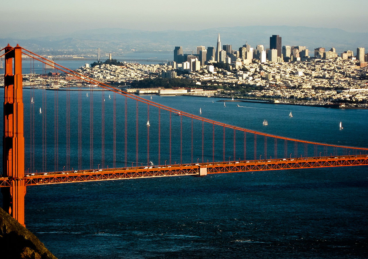

Notes
- ^ Including Solimar Beach and Rincon Beach.
- ^ In California, the term "expressway" describes a divided highway with few cross-traffic points and no grade separations at intersections, according to SHC § 257.
- ^ Including Refugio State Beach, Arroyo Quemada Beach and Gaviota State Beach.
- ^ Greenfield, Soledad, Gonzales, Chualar, and Spence.
- ^ I-405 had the longest HOV lanes in all. However, as of 2025[update], those lanes are being converted to HOT lanes, with eventual plans to remove exemptions for carpool. This means that the Marin-Sonoma HOV lanes on US 101 would be the longest untolled system of its kind in the state.
References
- ^ a b c California Department of Transportation. "State Truck Route List". Sacramento: California Department of Transportation. Archived from the original (XLS file) on September 5, 2015. Retrieved June 30, 2015.
- ^ McNichol, Dan (2006). The Roads that Built America: The Incredible Story of the US Interstate System. New York: Sterling. p. 74. ISBN 1-4027-3468-9.
- ^ Bureau of Public Roads & American Association of State Highway Officials (November 11, 1926). United States System of Highways Adopted for Uniform Marking by the American Association of State Highway Officials (Map). 1:7,000,000. Washington, DC: United States Geological Survey. OCLC 32889555. Retrieved November 7, 2013 – via Wikimedia Commons.
- ^ a b Flores, Oscar (December 19, 2016). "Gaviota Coast officially designated State Scenic Highway status". KEYT-TV. Archived from the original on May 13, 2019. Retrieved May 12, 2019.
- ^ a b California Department of Transportation (August 2019). "Officially Designated State Scenic Highways and Historic Parkways" (XLSX). Sacramento: California Department of Transportation. Retrieved May 12, 2019.
- ^ a b c Tracy, Erin (December 21, 2008). "Long-awaited highway fix to be scrutinized". Times-Standard. Retrieved March 16, 2012.[permanent dead link]
- ^ a b c "Walters: The runaround on coastal bypass debates". Santa Rosa Press Democrat. September 3, 2014. Retrieved November 20, 2021.
- ^ Faigin, Daniel P. "Highway Statistics". California Highways. Retrieved July 15, 2011.[self-published source]
- ^ Masters, Nathan (November 10, 2015). "Why Southern Californians Love Saying 'the' Before Freeway Numbers". KCET. Retrieved August 4, 2017.
- ^ "Section 401". California Streets and Highways Code. Sacramento: California Office of Legislative Counsel. Retrieved August 17, 2025.
- ^ American Association of State Highway and Transportation Officials. United States Numbered Highways (1989 ed.). Washington, DC: American Association of State Highway and Transportation Officials. Archived from the original on March 20, 2013.
- ^ Federal Highway Administration (March 25, 2015). National Highway System: California (South) (PDF) (Map). Scale not given. Washington, DC: Federal Highway Administration. Retrieved October 7, 2017.
Federal Highway Administration (March 25, 2015). National Highway System: California (North) (PDF) (Map). Scale not given. Washington, DC: Federal Highway Administration. Retrieved October 7, 2017.
Federal Highway Administration (March 25, 2015). National Highway System: San Francisco–Oakland, CA (PDF) (Map). Scale not given. Washington, DC: Federal Highway Administration. Retrieved July 14, 2025. - ^ Natzke, Stefan; Neathery, Mike & Adderly, Kevin (June 20, 2012). "What is the National Highway System?". National Highway System. Washington, DC: Federal Highway Administration. Retrieved July 1, 2012.
- ^ "Article 2 of Chapter 2 of Division 1". California Streets and Highways Code. Sacramento: California Office of Legislative Counsel. Retrieved February 6, 2019.
- ^ "Article 2.5 of Chapter 2 of Division 1". California Streets & Highways Code. Sacramento: California Office of Legislative Counsel. Retrieved February 6, 2019.
- ^ California Department of Transportation (2012). Scenic Highway Guidelines (PDF). Sacramento: California Department of Transportation. p. 5. Retrieved June 8, 2017.
- ^ Warchol, Richard (November 24, 1997). "Some Freeways Have Taken a Turn Toward Confusion". Los Angeles Times. p. B1. Retrieved August 3, 2023.
- ^ "HOV lane hours to be uniform in Marin, Sonoma counties". Caltrans. May 2025. Retrieved July 31, 2025.
- ^ a b c California Department of Transportation (2013). 2013 Named Freeways, Highways, Structures and Other Appurtenances in California (PDF). California Department of Transportation. p. 83. Archived from the original (PDF) on July 1, 2015. Retrieved June 13, 2014.
- ^ a b "Editorial: Bagley's legacy reveals a connection to all". Marin Independent Journal. June 29, 2025. Retrieved August 23, 2025.
- ^ Sonoma County General Plan 2020 Open Space Community Separators at the Wayback Machine (archived 8 February 2010)
- ^ Summit information by district, county, route, and postmile, California Department of Transportation, archived from the original on March 1, 2017, retrieved December 4, 2019
- ^ "SM 101 Express Lanes Project". California Department of Transportation. Retrieved February 12, 2022.
- ^ "Fastrak Toll Collection Coming To New Hwy 101 Express Lanes At End Of 2021". SFGATE. June 17, 2021.
- ^ "US 101 Express Lanes". 511.org. Metropolitan Transportation Commission. Retrieved March 2, 2023.
- ^ "US 101 Express Lanes Project (Phase 5)". Santa Clara Valley Transportation Authority. June 28, 2020. Retrieved March 2, 2023.
- ^ a b "101/SR-85 Santa Clara County Express Lanes". California Department of Transportation. Retrieved January 1, 2026.
- ^ a b "101 San Mateo Express Lanes". California Department of Transportation. Retrieved January 1, 2026.
- ^ "Invoices and Penalties". www.bayareafastrak.org. CalTrans. Retrieved January 12, 2025.
- ^ "Golden Gate Bridge". www.bayareafastrak.org. California Department of Transportation. Retrieved August 14, 2022.
- ^ National Park Service. "Plan Your Visit". Juan Bautista de Anza National Historic Trail. National Park Service. Retrieved September 9, 2010.
- ^ Simon, Richard (December 19, 1994). "Hollywood Freeway Spans Magic and Might of L.A." Los Angeles Times.
- ^ Starr, Kevin (2009). Golden Dreams: California in an Age of Abundance, 1950–1963. New York: Oxford University Press. p. 3.
- ^ Corwin, Miles (April 19, 1988). "Signal Removal on US 101 Gets Green Light After 34 Years". Los Angeles Times. Retrieved December 19, 2014.
- ^ "Lights Out on an Era: Roads: After 40 Years, the Final Traffic Signal on US 101 in Santa Barbara Is Coming Down. There Will Be an Uninterrupted Freeway Along the Coast Between Los Angeles and San Francisco". Los Angeles Times. November 19, 1991. Retrieved March 17, 2015.
- ^ King, John (January 3, 2007). "An Urban Success Story: Octavia Boulevard an Asset to post-Central Freeway Area". San Francisco Chronicle.
- ^ Sinclair, J.P. (March–April 1960). "Freeways in District IV". California Highways and Public Works. Vol. 39, no. 3–4. pp. 13–32. ISSN 0008-1159. Retrieved August 2, 2015 – via Archive.org.
- ^ Kuhn, Tillo E. (1962). Public Enterprise Economics and Transport Problems. University of California Press. p. 200.
- ^ "All Lanes Open on 101—Finally". Morgan Hill Times. May 20, 2003. Archived from the original on July 14, 2011. Retrieved July 15, 2011.
- ^ "Hwy 101 Opening Just Weeks Away". Morgan Hill Times. February 18, 2003. Archived from the original on July 20, 2011. Retrieved July 15, 2011.
- ^ Staff (March 7, 2003). "US 101 Southbound to Open Next Friday". Morgan Hill Times. Archived from the original on July 14, 2011. Retrieved July 15, 2011.
- ^ "US 101 Speedway". The Gilroy Dispatch. May 29, 2003. Archived from the original on July 19, 2011. Retrieved July 15, 2011.
- ^ Herhold, Scott (2013). "Herhold: The Story Behind Joe Colla's Famous 1976 Highway Stunt". San Jose Mercury News. Retrieved October 10, 2014.
- ^ "Bill Text". Archived from the original on October 6, 2014. Retrieved October 10, 2014.
- ^ a b "National Register Information System". National Register of Historic Places. National Park Service. March 13, 2009. Retrieved April 19, 2010.
- ^ Hawk, Diane (2004). Touring the Old Redwood Highway: Humboldt County. Arcata, CA: Hawk Mountaintop Publishing. p. 48. ISBN 0-9672162-4-9.
- ^ "Bypass spells relief in Cloverdale". The Press Democrat. Santa Rosa, California. April 3, 1993. p. B1. Retrieved March 5, 2024 – via Newspapers.com.
- ^ a b Hart, Steve (April 4, 1994). "Cloverdale turns into 'new town'". The Press Democrat. Santa Rosa, California. pp. 1, 9. Retrieved March 5, 2024 – via Newspapers.com.
- ^ Kramer, Robin (March 9, 1994). "New freeway bypass open in one direction". Cloverdale Reveille. Cloverdale, California. Cloverdale Reveille. pp. 1, 10. Retrieved March 5, 2024 – via Newspapers.com.
- ^ Olney, Jennifer (August 8, 2013). "Construction Begins on Controversial Willits Bypass". San Francisco: KGO-TV. Retrieved July 13, 2017.
- ^ Olney, Jennifer (June 20, 2014). "Caltrans Ordered to Stop Work on Willits Bypass". San Francisco: KGO-TV. Retrieved July 30, 2014.
- ^ Frisbie, Phil Jr. (July 10, 2014). "Corps Lifts Permit Suspension on Willits Bypass Project". California Department of Transportation. Retrieved July 13, 2017.
- ^ Anderson, Glenda (November 3, 2016). "Willits Highway 101 Bypass Finally Opens to Traffic". The Press Democrat. Santa Rosa, CA. Retrieved July 13, 2017.
- ^ Carmona, Ariel Jr. (November 3, 2016). "Willits Bypass Finally Opens to Fanfare and Dedication to Fallen Hero". The Willits News. Retrieved July 13, 2017.
- ^ Anderson, Glenda (June 27, 2017). "Final Price of Willits Bypass $159 Million Higher than Reported". The Press Democrat. Santa Rosa, CA. Retrieved July 13, 2017.
- ^ "Route 101U: Postmile MEN 47.512 to MEN 48.933". Postmile Services Postmile Query Tool. Caltrans. Retrieved March 5, 2025.
- ^ Weinreb, Elaine. "Big Changes Considered for 101 Through Eureka". North Coast Journal. Retrieved November 20, 2021.
- ^ "Freeway wildlife corridor is feasible, study says". Visalia Times Delta. Associated Press. September 3, 2015. Retrieved May 26, 2021.
- ^ Guldimann, Suzanne (February 9, 2015). "Liberty Canyon wildlife crossing granted $1 million by SCC". Malibu Surfside News. Archived from the original on August 1, 2017. Retrieved September 12, 2015.
- ^ California Department of Transportation (2008). "2008 Named Freeways, Highways, Structures and Other Appurtenances in California" (PDF). California Department of Transportation. Archived from the original (PDF) on October 14, 2012. Retrieved January 29, 2013.
- ^ California State Legislature (March 12, 2008). "ACR 116: Strickland. Adolfo Camarillo Memorial Highway". Legislative Counsel's Digest. Legislative Counsel of California. Retrieved May 11, 2014.
- ^ California Assembly Committee on Transportation. "Summary of Legislation". Archived from the original (DOC) on March 26, 2010. Retrieved January 29, 2013.
- ^ "Full speed ahead on Novato Narrows". Marin Independent Journal. July 19, 2018. Archived from the original on August 27, 2025. Retrieved October 6, 2025.
- ^ Rodriguez, Adrian (September 9, 2025). "Marin-Sonoma Narrows widening project hits 'huge milestone'". The Marin Independent Journal. Retrieved October 2, 2025.
- ^ Barmann, Jay (September 30, 2025). "Sonoma Commuters Rejoice as a 30-Year Freeway-Widening Project Gets Finally, Finally Finished". SFist. Retrieved October 2, 2025.
- ^ California Department of Transportation (July 2007). "Log of Bridges on State Highways". Sacramento: California Department of Transportation.
- ^ California Department of Transportation (2005–2006). "All Traffic Volumes on CSHS". California Department of Transportation.
- ^ California Department of Transportation. "U.S. Route 101 Freeway Interchanges" (PDF). California Numbered Exit Uniform System. California Department of Transportation. Retrieved February 7, 2009.
- ^ "California Highways: US 101". www.cahighways.org. Retrieved December 28, 2021.
- ^ a b c d e f California Department of Transportation. "2014 Named Freeways, Highways, Structures and Other Appurtenances in California" (PDF). California Department of Transportation. Archived from the original (PDF) on July 1, 2015. Retrieved June 20, 2015.
- ^ "Cahuenga Pass". Google Street View. Retrieved September 8, 2022.
- ^ Cornfield, Gregory (October 14, 2014). "Barham offramp to close permanently this weekend". Beverly Press & Park Labrea News. Beverly Hills, CA.
- ^ "US-101 — Wallis Annenberg Wildlife Crossing at Liberty Canyon". Caltrans. State of California. Retrieved November 22, 2023.
- ^ a b c d "Elevation and Location of Summits and Passes in California". California Department of Transportation. Archived from the original on March 1, 2017.

.svg)
External links
- Caltrans: US 101 highway conditions
- Caltrans Traffic Conditions Map
- California Highway Patrol Traffic Incidents
- Bay Area FasTrak – includes toll information on the US 101 Express Lanes, the Golden Gate Bridge and the other Bay Area toll facilities
- Drive the 101: historical information website
- California @ AARoads.com – U.S. Route 101
- California Highways: US 101